New Mobile Site
We have just launched a new mobile version of this site - m.trainspots. This page will use your smart device's GPS to loctate you and guide you to locations that are close to your present location.
Location notes
This page is a guide to the viewing locations. The type of photograph you will get from these locations will be more of a train in the urban landscape as opposed to a close up view. Telephoto lenses are required as the distance between you and the subject can be measured in miles as opposed to feet.
Newport is a large town in Gwent, South Wales. It is situated on the Great Western Main Line between the Severn Tunnel and Cardiff. It is also adjacent to the M4 motorway.
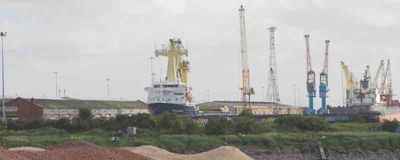
The Docks are located south of the town centre and station alongside where the River Usk joins the Severn Estuary.
Newport is a large town in Gwent, South Wales. It is situated on the Great Western Main Line between the Severn Tunnel and Cardiff. It is also adjacent to the M4 motorway.
The Docks are located south of the town centre and station alongside where the River Usk joins the Severn Estuary.
Railway type and traffic
Rail traffic on the GWML is a mix of freight and local, medium-distance and inter-city passenger traffic. The Docks branch leaves the GWML at Alexandra Dock Junction. The branch sees occasional coal traffic conveyed in HAA and HTA wagons. The branch is also used for removing newly-imported locomotives from South Dock onto the national network.
Environment
There are two recognised vantage points for the part of the Docks where locomotives are unloaded and commissioned. These are:
The Gaer, a residential estate on a hill in the town.
The sand dock or terminal, a riverside viewpoint is on a public footpath through an area of scrub land, typical of a semi-derelict industrial area on the opposite bank of the River Usk to the Docks unloading point.
The Gaer, a residential estate on a hill in the town.
The sand dock or terminal, a riverside viewpoint is on a public footpath through an area of scrub land, typical of a semi-derelict industrial area on the opposite bank of the River Usk to the Docks unloading point.
Road directions
If approaching Newport by the M4 leave the motorway at either Junction 25A from the east or 26 from the west. Follow signs for either the railway station (if heading for the Gaer) or the Docks if heading for the River.
The vantage point from the Gaer is the top of Rupert Brooke Drive - note the arrows position in relation to the docks.
Be aware that this location is some two miles distant from the Docks and powerful binoculars and good atmospheric visibility are essential. Look for the white silos of the cement depot in the Docks as a marker - the unloading area is just a little further away on the same line of sight. It is highly unlikely numbers will be visible from this distance - but individual locomotives should be visible once the ship has departed.
If wishing to see numbers the best opportunity is during unloading from the Riverside is from the Corporation Road vantage point - note the arrows position in relation to the docks.
Again, powerful binoculars will be required as the locomotives are visible at about 600 metres as they are lifted from the ship and before they are lowered to the quayside. Once the locomotives have been lowered they will not be visible until the ship has departed and even then they may be obscured by coal wagons, bushes or each other.
To reach this vantage point, follow the A4042 (signed Docks) from the motorway until reaching a T-junction with the A48 at traffic lights. Turn left on the A48, cross the River Usk on a bowstring bridge and bear immediately left, then right to cross the A48. This is necessary because there is no right turn at this junction on the A48. Follow Corporation Road for approximately 1 mile, passing under a railway bridge. Pass the sand terminal on your left and park before reaching the end of the road at Marshalls Brick depot. The footpath to the riverbank leaves this road on the left here.
Be aware that if using the M4 from England both bridges across the River Severn (either M4 or M48) charge a toll, currently in excess of £5 for a private car. The toll is payable westbound only. You will only need to cross one bridge!
Click here to set up your location for directions to this location
Newport South Docks, viewing points map co-ordinates
Parking
The Gaer is a residential area with no parking restrictions. There is no need to leave your car unattended as viewing takes place from the roadway.
Parking for the riverbank is unrestricted but be aware there are LGVs passing to and from the sand terminal and Marshalls so parking sensibly so as not to block access is essential. Cars left here unattended should be safe in daylight.
Parking for the riverbank is unrestricted but be aware there are LGVs passing to and from the sand terminal and Marshalls so parking sensibly so as not to block access is essential. Cars left here unattended should be safe in daylight.
Public transport
Newport Transport buses 2/3/4 serve The Gaer from the town's bus station.
There is no public transport to the riverbank location.
Click here to set up your location for directions to this location
There is no public transport to the riverbank location.
Click here to set up your location for directions to this location
Amenities
No facilities on The Gaer, nor on the riverbank - although there are usually a couple of mobile burger bars on Corporation Road which do good food and give excellent value. These close at about 14:00.
Accommodation
None recommended but there is the usual selection available through local Tourist Information.
Sun Compass
Sun Compass using Suncalc by brought to you by Vladimir Agafonkin:
It might be necessary to adjust the time to suit your visit, this link should open with the current day.
Newport South Docks, viewing points
Streetmap links
Newport South Docks, viewing points general view map
Newport South Docks, viewing points close up map
Windows Local Live Link - image quality may vary
Newport South Docks, viewing points
It might be necessary to adjust the time to suit your visit, this link should open with the current day.
Newport South Docks, viewing points
Googly map
Newport South Docks, viewing points general view map
Newport South Docks, viewing points close up map
Windows Local Live Link - image quality may vary
Newport South Docks, viewing points
Who likes this location on facebook
Railway Gen Group
Photographic notes
Detailed photography is not an option from The Gaer, because of distance.
From the riverside, if any recognisable locomotive images are required then a lens with a minimum focal length of 300mm is probably needed. At this location, any photographs after midday will be tending into the sun.
From the riverside, if any recognisable locomotive images are required then a lens with a minimum focal length of 300mm is probably needed. At this location, any photographs after midday will be tending into the sun.
General views - All photographs © John Patston unless otherwise stated
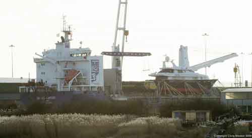
Fig 1 - Looking south east - Image © Chris Meaker
Viewed from Rupert Brooke Drive
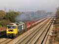
The ships crane lifts a loco from the hold to the dockside.
Fig 2 - Looking south east - Image © Chris Meaker
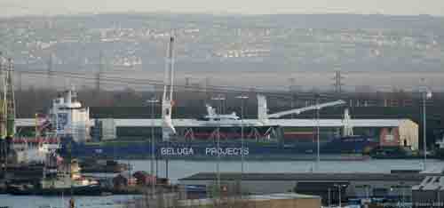
Viewed from Rupert Brooke Drive
The ship will obscure any locomotives on the dockside, unless they are shunted out of the view as per the 70 by the bow (right) of the ship here.
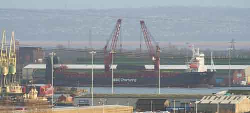
Fig 3 - Looking south east - Image © Chris Meaker
Viewed from Rupert Brooke Drive
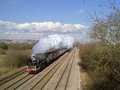
Once the ship is clear the locos are visible during commisioning.
Fig 4 - Looking south east - Image © Chris Meaker
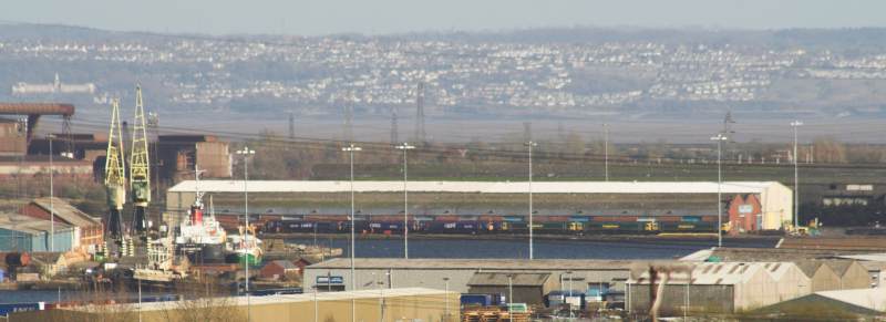
Viewed from Rupert Brooke Drive
A larger view showing the distance. Powerful binoculars, perhaps mounted on a tripod, are essential for identification purpose here.
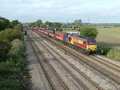
Fig 5 - Looking south west - Image © Chris Meaker
Viewed from Corporation Road, across the Usk
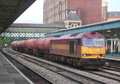
Unloading locos from the boat.
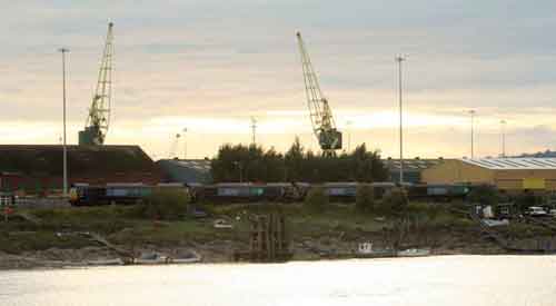
Fig 6 - Looking south west - Image © Chris Meaker
Viewed from Corporation Road, across the Usk
Once the ship has departed locos are visible on the quayside.
Fig 7 - Looking south west - Image © Chris Meaker
Viewed from Corporation Road, across the Usk
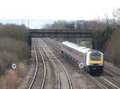
When the locos depart a view can be had of them on the docks lines.
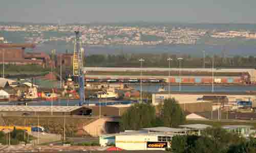
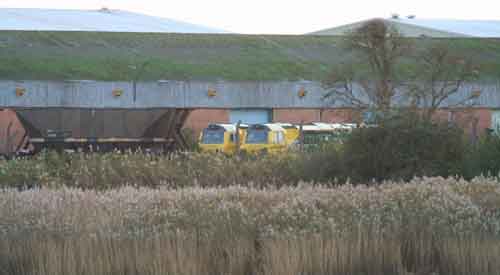
Fig 8 - Looking south west - Image © Chris Meaker
Viewed from Corporation Road, across the Usk
When the locos depart a view can be had of them on the docks lines although trees can be an issue.
Disclaimer
All information contained within this is site is © Trainspots. The images used on this site remain the property of the original photographer, as credited at the top of the page, and are used with their kind permission.
The information on these pages is supplied for the benefit of railway enthusiasts who carry out a harmless hobby, and through the medium of photography and video, actually promote the railway industry. Railway enthusiasts can also act as eyes and ears against railway vandalism, and as such should surely be encouraged to do so by the supply of adequate information such as is found on this website.
This site has been created to assist railway photographers in their travels around the country. It is based on the personal knowledge and experience. No liability can be held against the web site or its contributions for incorrect information. Trainspots will endeavour to check all information and corrections will be accepted and posted accordingly.
Advice as to the locations general environment is given as a guide on each page. This information is a GUIDE only. ALWAYS be careful with your equipment, Trainspots can not be held responsible for your personal security. Avoid leaving your property on display for all to see, be aware of your surroundings at all times. There are, sadly, people who will not think twice about trying to steal your equipment.
Trainspots DOES NOT condone trespass and none of the information on this site should be taken as a right to trespass on either railway or private land. To the best of our knowledge all locations are publicly accessible areas, where they are not contact information will be given to the appropriate authority for permission to be obtained.
The content of this site is created and intended for all age ranges but the content of sites linked from this site are not subject to the same intentions. Trainspots will attempt to check links for validity but as time passes and the site grows this will not always be possible. Broken, or indeed updates to, links should be submitted to the editor for inclusion in the updates. All links external to the Trainspots site are opened in a new browser window. Trainspots has been running now for over 10 years and there are imitation sites and guides to railfotspots. But we are a free site and we continue on the path we started out on over a decade ago to provide a useful guide to UK Railway Photographic Locations.