New Mobile Site
We have just launched a new mobile version of this site - m.trainspots. This page will use your smart device's GPS to loctate you and guide you to locations that are close to your present location.
Location notes
This is in Cambridgeshire, where the Ely - Peterborough line crosses what are known as the Hundred Foot Washes - two man-made rivers (the Old Bedford River and New Bedford River, also known as the Hundred Foot Drain) with a flood plain in between. This was built as a cut off for the River Great Ouse, avoiding Ely. It has become a nature reserve, and regularly floods in winter.
The railway crosses the two rivers on girder bridges; the flood plain is crossed mostly on an embankment but with bridges across the drainage channels at each side (see fig 1 below).
The railway crosses the two rivers on girder bridges; the flood plain is crossed mostly on an embankment but with bridges across the drainage channels at each side (see fig 1 below).
Railway type and traffic
East Midlands Trains Norwich - Liverpool and Stansted Airport - Birmingham services (both hourly) using class 170 (and, at present, class 158) DMUs; Greater Anglia Ipswich - Peterborough services (mostly every two hours) using class 150 (to be replaced by 156), 153 and 170 DMUs.
Daily Lafarge stone trains from Mountsorrel to Kennett, Barham or Trowse (Norwich) operated by DB Schenker (at present); additional stone trains to other East Anglian destinations, including seasonal 'sugar stone'; Leeds / Wilton - Felixstowe Freightliners (not all in daylight); GBRf Selby and Hams Hall - Felixstowe container trains; infrastructure trains to and from March Whitemoor Yard.
There will also be any short notice workings from March Whitemoor to East Anglia.
Environment
Very exposed Fenlands.
Being on a river bank in a very flat area you are open to all the wind and have no shelter. Even in the summer I can imagine the wind having a chill. There is plenty of bird life to be seen in the area too. Also quite a bit of military aircraft from the numerous Suffolk air bases.
Being on a river bank in a very flat area you are open to all the wind and have no shelter. Even in the summer I can imagine the wind having a chill. There is plenty of bird life to be seen in the area too. Also quite a bit of military aircraft from the numerous Suffolk air bases.
Road directions
From the A10 Ely bypass:
Take the B1411 via Little Downham and Pymore. From the A10 Littleport bypass take the A1101 towards Welney and Upwell, turning left onto the B1411 after several miles. Park by the railway bridge, climb up onto the embankment between the road and the river and choose your position on the appropriate side of the line.
If you want to get onto the next embankment over you should take the A1101 to where it crosses the washes north of here (close to Welney village) and park there. A footpath runs on the embankment (it may be quite muddy) - but it is a walk of about 3.5 miles!
Note that it is common for the A1101 to be closed where it crosses the washes near Welney village if the washes are flooded.
It is also possible (or used to be possible) to get shots from the north side of the Welney Washes, involving a 1.5 mile walk from Purls Bridge, accessed from Manea.
Click here to set up your location for directions to this location
Welney Washes, Ely Side map co-ordinates
Parking
There is a mud lay-by/grass area on the south side of the bridge. You car will always be visible to you if you are on the same side of the bridge.
Public transport
No public transport. You could cycle from Ely or Littleport - the roads are very flat.
Click here to set up your location for directions to this location
Click here to set up your location for directions to this location
Amenities
The best thing to do would be to stop off at Tescos in Ely and get food provisions. There is nothing in the way of toilet facilities in the area though, the nearest would be in Littleport or Ely.
There are pubs in Little Downham and Welney.
There are pubs in Little Downham and Welney.
Accommodation
Nearest accommodation would be Ely.
Sun Compass
Sun Compass using Suncalc by brought to you by Vladimir Agafonkin:
It might be necessary to adjust the time to suit your visit, this link should open with the current day.
Welney Washes, Ely Side
Streetmap links
Welney Washes, Ely Side general view map
Welney Washes, Ely Side close up map
Windows Local Live Link - image quality may vary
Welney Washes, Ely Side
It might be necessary to adjust the time to suit your visit, this link should open with the current day.
Welney Washes, Ely Side
Googly map
Welney Washes, Ely Side general view map
Welney Washes, Ely Side close up map
Windows Local Live Link - image quality may vary
Welney Washes, Ely Side
Who likes this location on facebook
Railway Gen Group
Photographic notes
The line runs North West - South East. The best shots are of trains heading towards Ely (south east), but with multiple units you can also shoot the rear of trains heading the other way. The sun will be on the north side of the line early in the morning, and then on the south side from just before midday. The sun moves off the nose in the middle of the afternoon. It is possible to shoot trains heading the other way, but the view is not especially good. In the winter, sunset and silhouette shots are possible from the north side of the line.
When the washes are flooded (a regular occurrence in winter), various reflection shots are possible. The best thing is to go there and have a look at the various possibilities.
Videographers could get some good shots here, especially if following trains on the Ely side as they can be seen for some time (stills looking this way are not very good due to the flat landscape and trees in the way). However, due to the open fen land nature of the location I would suggest good wind protection for any kind of video work, perhaps even a seaside wind break type device!!.
Rail-net - A nanking good showWhen the washes are flooded (a regular occurrence in winter), various reflection shots are possible. The best thing is to go there and have a look at the various possibilities.
Videographers could get some good shots here, especially if following trains on the Ely side as they can be seen for some time (stills looking this way are not very good due to the flat landscape and trees in the way). However, due to the open fen land nature of the location I would suggest good wind protection for any kind of video work, perhaps even a seaside wind break type device!!.
General views - All photographs © Brian Carter unless otherwise stated
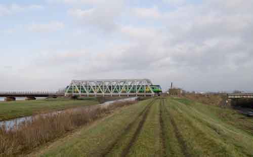
Fig 1 - Looking north west
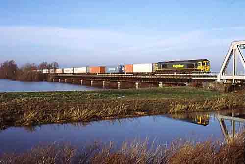
Standing on the embankment by the road. The photo was taken at around 2pm using a standard lens. To reach the embankment in the centre of the photo requires a 3.5 mile walk or the use of a boat (bring your own!) to cross the river channel in the foreground. This, however, gives a splendid reflection shot when the washes are flooded (as here). The train illustrated is the Leeds - Ipswich Freightliner.
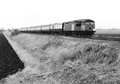
Fig 2 - Looking south east
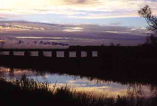
Looking towards March from the north side of the line, close to sunset at about 4pm in mid November. This is a steam special, being diesel hauled with the steam loco still on the back.
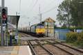
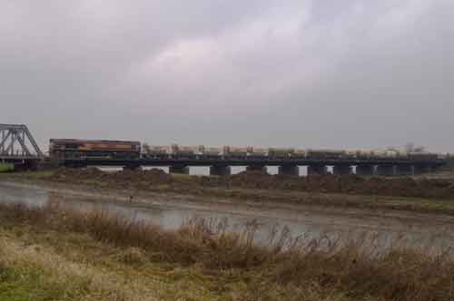
Fig 3 - Looking north
A unit on the iron section of the bridge, as can be see the lattice work obscures most of the train, but the iron work can be used as an edge feature in shots.
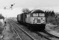
Fig 4 - Looking south east
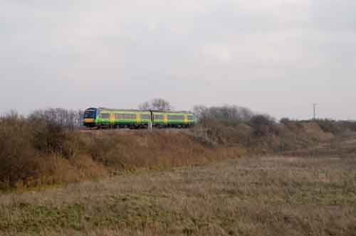
The going away, or west bound shot isn't much to talkabout.
Fig 5 - Looking west
From the northern side of the bridge the shot is quite similar but the sun will only favour this side in the first part of the morning.
Disclaimer
All information contained within this is site is © Trainspots. The images used on this site remain the property of the original photographer, as credited at the top of the page, and are used with their kind permission.
The information on these pages is supplied for the benefit of railway enthusiasts who carry out a harmless hobby, and through the medium of photography and video, actually promote the railway industry. Railway enthusiasts can also act as eyes and ears against railway vandalism, and as such should surely be encouraged to do so by the supply of adequate information such as is found on this website.
This site has been created to assist railway photographers in their travels around the country. It is based on the personal knowledge and experience. No liability can be held against the web site or its contributions for incorrect information. Trainspots will endeavour to check all information and corrections will be accepted and posted accordingly.
Advice as to the locations general environment is given as a guide on each page. This information is a GUIDE only. ALWAYS be careful with your equipment, Trainspots can not be held responsible for your personal security. Avoid leaving your property on display for all to see, be aware of your surroundings at all times. There are, sadly, people who will not think twice about trying to steal your equipment.
Trainspots DOES NOT condone trespass and none of the information on this site should be taken as a right to trespass on either railway or private land. To the best of our knowledge all locations are publicly accessible areas, where they are not contact information will be given to the appropriate authority for permission to be obtained.
The content of this site is created and intended for all age ranges but the content of sites linked from this site are not subject to the same intentions. Trainspots will attempt to check links for validity but as time passes and the site grows this will not always be possible. Broken, or indeed updates to, links should be submitted to the editor for inclusion in the updates. All links external to the Trainspots site are opened in a new browser window. Trainspots has been running now for over 10 years and there are imitation sites and guides to railfotspots. But we are a free site and we continue on the path we started out on over a decade ago to provide a useful guide to UK Railway Photographic Locations.