New Mobile Site
We have just launched a new mobile version of this site - m.trainspots. This page will use your smart device's GPS to loctate you and guide you to locations that are close to your present location.
Location notes
A fairly new overbridge in south Cambridge, north of Shepreth Branch Junction where the two routes from Cambridge to London split.
Railway type and traffic
Frequent EMUs operated by Great Northern (317s, 321s and 365s) and Abellio Greater Anglia (317s and 379s), plus hourly class 170 DMUs operated by Cross Country. There's a very small amount of scheduled freight, plus less regular engineers' trains to and from Whitemoor.
Environment
The bridge was built to carry the Cambridgeshire Guided Busway's Addenbrooke's Hopsital branch over the railway line, and is right next to the Cambridge Biomedical Campus which includes Addenbrooke's Hospital. It also replaced a foot and cycle crossing, which has now been closed. The double track guided busway is on the north side of the bridge, with the foot and cycle path on the south side. The area is open (at present), although new housing is planned (and some partly built).
Road directions
From the M11 junction 11:
Take the A1309 towards Cambridge. After passing the Trumpington Park and Ride (on your left) and Waitrose (also on your left), you enter Trumpington; take the first right after the next set of traffic lights - Anstey Way (there are some shops on the corner). At the T junction (with a large grassed area in front of you), turn left (Paget Road), and follow this road - it bends sharply to the right. At the next sharp right-hand bend park up in the short cul-de-sac on the left and walk from here. Follow the footpath, which crosses a short non-guided section of the busway and leads up to the bridge - walking time is about 5-10 minutes.
Click here to set up your location for directions to this location
Addenbrooke's Hospital busway bridge, Cambridge map co-ordinates
Parking
You are parked in a residential area, but cannot see the car from the bridge - so take the usual precautions. Car crime is low in this area.
Public transport
Best way is by bus or guided bus to Addenbrooke's Hospital, and walk the short distance from there. The guided bus runs from Cambridge city centre, and passes Cambridge railway station en route. Make sure you catch a bus going to Addenbrooke's Hospital, and not Trumpington Park and Ride. You could also walk from Shelford station, but it's quite a distance: follow the cycle (and foot) path which runs on the east side of the line (head east along the road from Shelford station and take the first left to access the cycle path).
Click here to set up your location for directions to this location
Click here to set up your location for directions to this location
Amenities
No toilets known of nearby. There are shops (including food) in Trumpington (on the corner of Anstey Way), and some in Addenbrooke's Hospital. Plenty of shops in central Cambridge. Pubs in Trumpington, plus a Chinese restaurant.
Accommodation
Plenty of accommodation in and around Cambridge (including several Travelodges).
Sun Compass
Sun Compass using Suncalc by brought to you by Vladimir Agafonkin:
It might be necessary to adjust the time to suit your visit, this link should open with the current day.
Addenbrooke's Hospital busway bridge, Cambridge
Streetmap links
Addenbrooke's Hospital busway bridge, Cambridge general view map
Addenbrooke's Hospital busway bridge, Cambridge close up map
Windows Local Live Link - image quality may vary
Addenbrooke's Hospital busway bridge, Cambridge
It might be necessary to adjust the time to suit your visit, this link should open with the current day.
Addenbrooke's Hospital busway bridge, Cambridge
Googly map
Addenbrooke's Hospital busway bridge, Cambridge general view map
Addenbrooke's Hospital busway bridge, Cambridge close up map
Windows Local Live Link - image quality may vary
Addenbrooke's Hospital busway bridge, Cambridge
Who likes this location on facebook
Railway Gen Group
Photographic notes
The line runs almost north-south here, but shots from the east side of the line are not very good. Best in the afternoon from the west side looking both north and south, where the line is (at the time of writing) clear of vegetation. The sun moves round onto the front of northbound trains at around 5-6pm. No steps are required, as you are not looking over the bridge parapet.
Note that the footpath is on the south side of the bridge. Therefore to take photos looking northwards, it's necessary to cross the guided busway tracks. There is a spot to stand which is clear of the tracks, but it's probably better to be on the other side of the wooden fence (either climb over or walk round the end and along the side of the bank). Going a short way down the bank allows southbound trains to be unobscured by the overhead wires.
At the time of writing, because the area is so open, photography is possible until sunset (even 9pm in June) - there are no shadows across the tracks. However, with further housing developments planned, this is likely to change over the next few years.
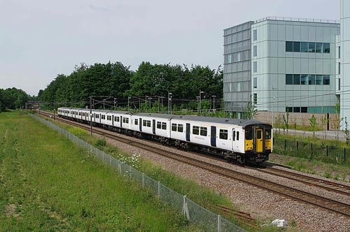
General views - All photographs © Brian Carter unless otherwise stated
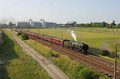
Fig 1 - Looking south
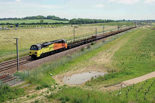
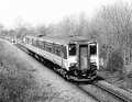
Fig 2 - Looking north
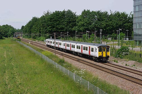
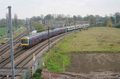
Fig 3 - Looking north
Disclaimer
All information contained within this is site is © Trainspots. The images used on this site remain the property of the original photographer, as credited at the top of the page, and are used with their kind permission.
The information on these pages is supplied for the benefit of railway enthusiasts who carry out a harmless hobby, and through the medium of photography and video, actually promote the railway industry. Railway enthusiasts can also act as eyes and ears against railway vandalism, and as such should surely be encouraged to do so by the supply of adequate information such as is found on this website.
This site has been created to assist railway photographers in their travels around the country. It is based on the personal knowledge and experience. No liability can be held against the web site or its contributions for incorrect information. Trainspots will endeavour to check all information and corrections will be accepted and posted accordingly.
Advice as to the locations general environment is given as a guide on each page. This information is a GUIDE only. ALWAYS be careful with your equipment, Trainspots can not be held responsible for your personal security. Avoid leaving your property on display for all to see, be aware of your surroundings at all times. There are, sadly, people who will not think twice about trying to steal your equipment.
Trainspots DOES NOT condone trespass and none of the information on this site should be taken as a right to trespass on either railway or private land. To the best of our knowledge all locations are publicly accessible areas, where they are not contact information will be given to the appropriate authority for permission to be obtained.
The content of this site is created and intended for all age ranges but the content of sites linked from this site are not subject to the same intentions. Trainspots will attempt to check links for validity but as time passes and the site grows this will not always be possible. Broken, or indeed updates to, links should be submitted to the editor for inclusion in the updates. All links external to the Trainspots site are opened in a new browser window. Trainspots has been running now for over 10 years and there are imitation sites and guides to railfotspots. But we are a free site and we continue on the path we started out on over a decade ago to provide a useful guide to UK Railway Photographic Locations.