New Mobile Site
We have just launched a new mobile version of this site - m.trainspots. This page will use your smart device's GPS to loctate you and guide you to locations that are close to your present location.
Location notes
Felixstowe is Suffolk's, and indeed England's, largest port complex. Located at the coastal tip of a flat peninsula bordered by the Rivers Deben and Orwell and the North sea, with the county town of Ipswich on its northern inland edge. By road the port is about 10 miles west of Ipswich.
Railway type and traffic
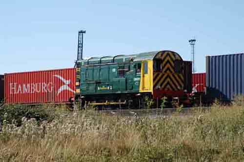
Being a container port most of the traffic is freightliners. DB Schenker, Freightliner and GBRf operate services. Motive power is predominantly class 66 based but there are also many class 70 Freightliner workings.
Link to Real Time Trains
RTT Link Felixstowe Central Docks
This link should be close to the location, but may not be the actual location so please check the page. This link will take you to what is happening 'around now'. Dates and times can be changed at the top of the page.
This link should be close to the location, but may not be the actual location so please check the page. This link will take you to what is happening 'around now'. Dates and times can be changed at the top of the page.
Environment
A seaside Suffolk town. Fairly quiet and sedate.
Road directions
From the A14, Junction 61:
If you are only planning a short visit.. Take the exit towards 'Dock gate No 2/Trinity Business Park' and follow the road round back under the A14 whilst keeping in the left hand lane. After the traffic lights keep right and take the turning to the cafe/petrol station where you can park for a limited time. Then you need to walk..
Continue on foot along Trinity Avenue and at the end of the road uirn right and contunue along Fagbury Road to the end and the Central Terminal is on your left.
For a longer stay it would be better to park on Cordys Lane in Trimley and walk back. See the TS182 Clickett Hill page for the A14 directions.
Click here to set up your location for directions to this location
Felixstowe Central Docks map co-ordinates
Parking
There are a couple of lorry parks and car parks off Parker Avenue. Fagbury road has double yellow lines along it. For a longer stay it would be recomended to park at the bottom of Cordys Lane and walk down the public footpath to the location. This would be around a mile to walk. You would also pass Clickets Hill on the walk. Cordys Lane runs past Trimley station, if you continue over the level crossing to the end of the road you will find the parking area and from there follow the 'Blofield Track' to the location.
Public transport
Amenities
There are plenty of fish and chip shops on the sea front and a McDonalds drive through is located off the first roundabout into Felixstowe.
Accommodation
Sun Compass
Sun Compass using Suncalc by brought to you by Vladimir Agafonkin:
It might be necessary to adjust the time to suit your visit, this link should open with the current day.
Felixstowe Central Docks
Streetmap links
Felixstowe Central Docks general view map
Felixstowe Central Docks close up map
Windows Local Live Link - image quality may vary
Felixstowe Central Docks
It might be necessary to adjust the time to suit your visit, this link should open with the current day.
Felixstowe Central Docks
Googly map
Felixstowe Central Docks general view map
Felixstowe Central Docks close up map
Windows Local Live Link - image quality may vary
Felixstowe Central Docks
Who likes this location on facebook
Railway Gen Group
Photographic notes
There are two vantage points here
The road side - fig 1 >4:
There is a high chain mesh fence here. Wide shots from across the road will avoid this, or steps are required.
From the embankments - Fig 5 > 8:
This location is on the footpath between the docks and Trimley. The walk is described in the East Suffolk Line Walks page and the walk passes through Clicketts Hill. Just at the end of Fagburys Road there is a gate across the railway lines. Follow this and follow the path (dirt track) up a hill running parallel with the railway line. When you reach open fields the curve is behind a row of hedges. There are a number of gaps in this hedge to get through (there are brambles in places!) and here you will see the curve. Following the path Towards Clicketts Hill there are a number of photographic options available. The grade is quite steep coming out of the docks so a loaded liner will be working quite hard to get it's train moving and climb the grade.
Since the opening of the new North Terminal the gates to the footpath have magnetic locks allowing them to be kept closed, for reasons of safety, during the frequent train movements. This also means that the gates can be locked for a considerable amount of time. People have reported been 'trapped' in the central refuge for over an hour in the past. The footpath is also monitored by the port police using CCTV at the crossing and there is a phone number to call to tell them you are 'trapped', but you may be in for a wait to be released.
Links to photographs at this location
Rail-net - GB tour Day 5
General views - All photographs © Marcus Dawson unless otherwise stated
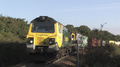
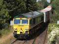
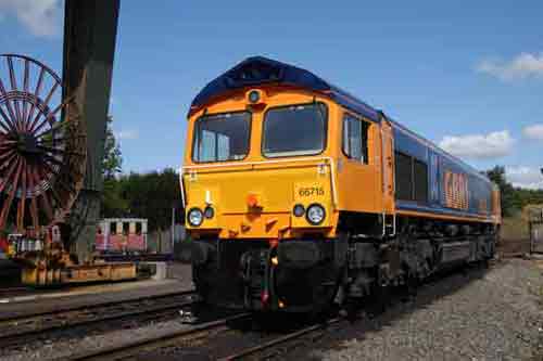
Fig 1- Facing North
The dock loading area has some a large container crane that looms over any train in the yard.
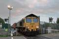
Fig 2 - Facing south
Reverse of the fig 1.
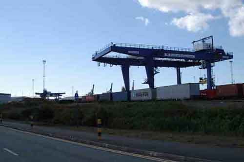
Fig 3 - Zoom shot
From the opposite side of the road, but from the same spot as fig 2, you can get a view without having the chain link fence in the way. You can see the fence running along the bottom of this shot.
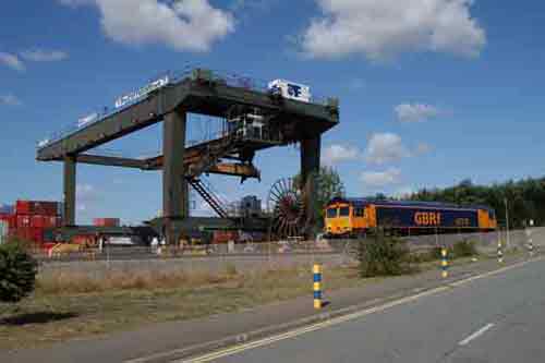
Fig 4 - Over the fence
Or you can use steps to get a view over the fence, although be warned there is barbed wire at the top of the fence.
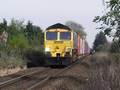
Fig 5 - Looking north east
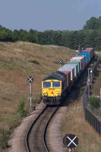
From the top of the bank a liner descends into the Docks.
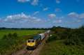
Fig 6 - Looking south east
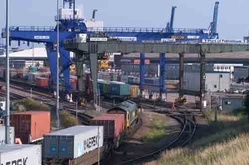
This view shows the train arriving on the docks. The public foot path runs just infront of where the loco is positioned.
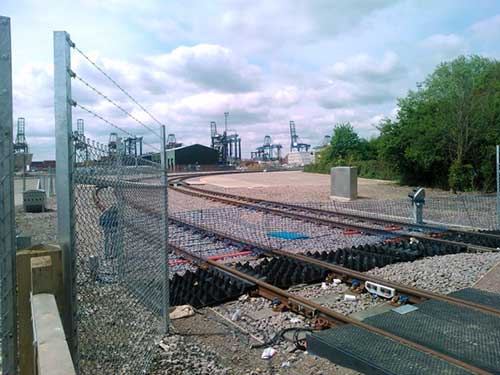
Fig 7 - Looking north east
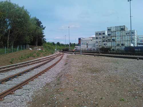
From the center section of the public footpath. This view shows the new line on the left for the North Terminal and the original lines on the right. This shot was taken between the two lines in a gated refuge on the path.
The triangle in the middle of the lines has weeds growing in it which will make this shot almost impossible in the summer.
Fig 8 - Looking south west
The line from the north terminal curves round and crosses the footpath at this point.
Disclaimer
All information contained within this is site is © Trainspots. The images used on this site remain the property of the original photographer, as credited at the top of the page, and are used with their kind permission.
The information on these pages is supplied for the benefit of railway enthusiasts who carry out a harmless hobby, and through the medium of photography and video, actually promote the railway industry. Railway enthusiasts can also act as eyes and ears against railway vandalism, and as such should surely be encouraged to do so by the supply of adequate information such as is found on this website.
This site has been created to assist railway photographers in their travels around the country. It is based on the personal knowledge and experience. No liability can be held against the web site or its contributions for incorrect information. Trainspots will endeavour to check all information and corrections will be accepted and posted accordingly.
Advice as to the locations general environment is given as a guide on each page. This information is a GUIDE only. ALWAYS be careful with your equipment, Trainspots can not be held responsible for your personal security. Avoid leaving your property on display for all to see, be aware of your surroundings at all times. There are, sadly, people who will not think twice about trying to steal your equipment.
Trainspots DOES NOT condone trespass and none of the information on this site should be taken as a right to trespass on either railway or private land. To the best of our knowledge all locations are publicly accessible areas, where they are not contact information will be given to the appropriate authority for permission to be obtained.
The content of this site is created and intended for all age ranges but the content of sites linked from this site are not subject to the same intentions. Trainspots will attempt to check links for validity but as time passes and the site grows this will not always be possible. Broken, or indeed updates to, links should be submitted to the editor for inclusion in the updates. All links external to the Trainspots site are opened in a new browser window. Trainspots has been running now for over 10 years and there are imitation sites and guides to railfotspots. But we are a free site and we continue on the path we started out on over a decade ago to provide a useful guide to UK Railway Photographic Locations.