New Mobile Site
We have just launched a new mobile version of this site - m.trainspots. This page will use your smart device's GPS to loctate you and guide you to locations that are close to your present location.
Location notes
Situated on the Ely to Norwich line, between Brandon and Thetford stations in Norfolk. The level crossing mentioned below is officially 'Santon' on the railway.
Railway type and traffic
Passenger:
Central Trains Liverpool - Norwich (hourly) and Greater Anglia Cambridge - Norwich (hourly), both usually with class 170 DMUs (but some Central Trains services are still 158s).
Freight:
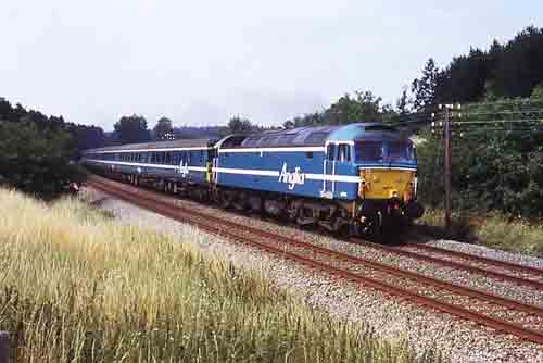
Very limited - Mountsorrel - Trowse (Norwich) Lafarge stone train 2 or 3 times a week (runs early afternoon at present - perfect for this location), operated (at October 2004) by DB Schenker using class 66 locos (but rumours abound of a Freightliner Heavy Haul takeover), plus occasional short term contract stone trains to Eccles Road (usually Freightliner) and the seasonal 'sugar stone' to Trowse (DB Schenker).
Central Trains Liverpool - Norwich (hourly) and Greater Anglia Cambridge - Norwich (hourly), both usually with class 170 DMUs (but some Central Trains services are still 158s).
Freight:
Very limited - Mountsorrel - Trowse (Norwich) Lafarge stone train 2 or 3 times a week (runs early afternoon at present - perfect for this location), operated (at October 2004) by DB Schenker using class 66 locos (but rumours abound of a Freightliner Heavy Haul takeover), plus occasional short term contract stone trains to Eccles Road (usually Freightliner) and the seasonal 'sugar stone' to Trowse (DB Schenker).
Environment
Location is in the middle of Thetford Forest, well away from any built-up area. In the summer the location is often quite busy with families on a day out.
Road directions
From Thetford or Norwich:
From A134 Thetford to Downham Market road, take the unclassified road signed Santon Downham (southwards) - this is the first proper left hand turn when coming from Thetford, and is almost 4 miles from the A11 roundabout. After nearly 2 miles turn left after crossing the railway level crossing, and continue to the signposted picnic area.
From Brandon:
Take the B1107 east from the town centre, forking left after a mile or so to follow the signs to Santon Downham. At the far end of the village turn left (signed Santon Warren). Just before you reach the level crossing, turn right and follow this road to the signposted picnic area.
Alternatively, if coming from Brandon station, the following longer route may be quicker (avoiding the traffic lights in Brandon town centre).
Head north from the station on the A1065 (the main road over the level crossing). After about 2 miles fork right onto the unclassified road signed Grimes Graves, and at the crossroads with the A134 turn right. Take the next right, signed Santon Downham, and turn left after the level crossing to reach the signposted picnic area.
Click here to set up your location for directions to this location
Thetford Forest, Santon map co-ordinates
Parking
On entering the picnic area, keep to the left and park in the left hand corner close to the railway line. Walk westwards through the trees into the open field. At the time of writing there was no car parking charge, but there was a ticket machine covered over, so it has either been discontinued or may be introduced in the future.
Public transport
No public transport, but Brandon is about 3 miles away - there are plenty of forest walks.
Click here to set up your location for directions to this location
Click here to set up your location for directions to this location
Amenities
The are public toilets here, but nothing else. Nearest shops are at Brandon, about 3 miles away (including a small supermarket) or Thetford a bit further the other way.
Accommodation
The nearest accommodation would probably be in Thetford.
Sun Compass
Sun Compass using Suncalc by brought to you by Vladimir Agafonkin:
It might be necessary to adjust the time to suit your visit, this link should open with the current day.
Thetford Forest, Santon
Streetmap links
Thetford Forest, Santon general view map
Thetford Forest, Santon close up map
Windows Local Live Link - image quality may vary
Thetford Forest, Santon
It might be necessary to adjust the time to suit your visit, this link should open with the current day.
Thetford Forest, Santon
Googly map
Thetford Forest, Santon general view map
Thetford Forest, Santon close up map
Windows Local Live Link - image quality may vary
Thetford Forest, Santon
Who likes this location on facebook
Railway Gen Group
Photographic notes
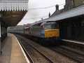
This is the best shot I know of in Thetford Forest, as others involve shooting from the shadowy side of the line or are taken from very close to the track and are more head-on. The line runs approximately NW-SE here, and shots are only possible of eastbound trains (or going away shots of westbound trains). The light is correct from mid morning onwards, with the sun on the nose until 2 or 3pm, and there should be no problems with shadows. Simply stand by the fence! Steps are not needed, but if there is a group of people might be useful for some in the group. This section of line still has telegraph poles with wires, and these can easily feature in the shot.
Shots of eastbound trains are also possible from near the level crossing mentioned in the 'Directions' section; park close to the level crossing (there is plenty of space). Either shoot from the crossing itself, or walk 100 yards or more eastwards between the trees and the fence. Steps will be very useful for this shot, but note that because the line curves from the left, the back of long trains will be lost out of the frame. However, the sun remains on the nose for longer here than at the picnic area, but shadows from trees would be more of a problem in winter.
There is plenty of warning of approaching trains as they can be heard shortly after leaving / passing through Brandon - the sound travels far in the forest.
Both of these locations would be alright for taking videos, but the film would be short due to the curved nature of the line and the lack of scope for panning round. The sound of the level crossing sirens will be noticeable all through shots taken at that location.
General views - All photographs © Brian Carter unless otherwise stated
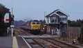
Fig 1 - Looking west
Taken at around 2pm in August 2004.
Since taking this photo, the tree which almost blocks the view of the back of the train has been cut back.
Disclaimer
All information contained within this is site is © Trainspots. The images used on this site remain the property of the original photographer, as credited at the top of the page, and are used with their kind permission.
The information on these pages is supplied for the benefit of railway enthusiasts who carry out a harmless hobby, and through the medium of photography and video, actually promote the railway industry. Railway enthusiasts can also act as eyes and ears against railway vandalism, and as such should surely be encouraged to do so by the supply of adequate information such as is found on this website.
This site has been created to assist railway photographers in their travels around the country. It is based on the personal knowledge and experience. No liability can be held against the web site or its contributions for incorrect information. Trainspots will endeavour to check all information and corrections will be accepted and posted accordingly.
Advice as to the locations general environment is given as a guide on each page. This information is a GUIDE only. ALWAYS be careful with your equipment, Trainspots can not be held responsible for your personal security. Avoid leaving your property on display for all to see, be aware of your surroundings at all times. There are, sadly, people who will not think twice about trying to steal your equipment.
Trainspots DOES NOT condone trespass and none of the information on this site should be taken as a right to trespass on either railway or private land. To the best of our knowledge all locations are publicly accessible areas, where they are not contact information will be given to the appropriate authority for permission to be obtained.
The content of this site is created and intended for all age ranges but the content of sites linked from this site are not subject to the same intentions. Trainspots will attempt to check links for validity but as time passes and the site grows this will not always be possible. Broken, or indeed updates to, links should be submitted to the editor for inclusion in the updates. All links external to the Trainspots site are opened in a new browser window. Trainspots has been running now for over 10 years and there are imitation sites and guides to railfotspots. But we are a free site and we continue on the path we started out on over a decade ago to provide a useful guide to UK Railway Photographic Locations.