New Mobile Site
We have just launched a new mobile version of this site - m.trainspots. This page will use your smart device's GPS to loctate you and guide you to locations that are close to your present location.
Location notes
Located on the West Coast Main Line on the 1 in 75 Shap incline, north of Tebay. This whole stretch of line has been famous for railway photography since steam days, and is still popular.
Railway type and traffic
About 60 trains a day between 05:00 and 22:00. Of these, about 3 /4 are Virgin West Coast or Cross Country services. All Cross Country trains are Voyagers. West Coast trains are almost always Pendolino worked.
Most freight trains run in the evenings or overnight. Daytime services mainly comprise intermodals and coal.
Most freight trains run in the evenings or overnight. Daytime services mainly comprise intermodals and coal.
Link to Real Time Trains
RTT Link Greenholme
This link should be close to the location, but may not be the actual location so please check the page. This link will take you to what is happening 'around now'. Dates and times can be changed at the top of the page.
This link should be close to the location, but may not be the actual location so please check the page. This link will take you to what is happening 'around now'. Dates and times can be changed at the top of the page.
Environment
Shap is hill farming country. There is no right to roam: visitors should keep to the public footpaths. The farmers have a sixth sense for strangers on their land, and will tackle trespassers. They particularly resent damage to property, especially walls and fences, and so-called gardening by photographers seeking to clear viewpoints. Culprits can expect police action.
Weather - Shap has a notoriously high rainfall and is very exposed to the elements. Come prepared!
Weather - Shap has a notoriously high rainfall and is very exposed to the elements. Come prepared!
Road directions
Drive to Tebay Services on the northbound M6. Walk out the back of the services past the Westmoreland Hotel and turn left to Scotchmans Bridge (5 minutes).
Click here to set up your location for directions to this location
Greenholme map co-ordinates
Click here to set up your location for directions to this location
Greenholme map co-ordinates
Parking
In Tebay Services
Public transport
Amenities
None at the location, the nearest ones are the Tebay services on the M6.
Sun Compass
Sun Compass using Suncalc by brought to you by Vladimir Agafonkin:
It might be necessary to adjust the time to suit your visit, this link should open with the current day.
Greenholme
Streetmap links
Greenholme general view map
Greenholme close up map
Windows Local Live Link - image quality may vary
Greenholme
It might be necessary to adjust the time to suit your visit, this link should open with the current day.
Greenholme
Googly map
Greenholme general view map
Greenholme close up map
Windows Local Live Link - image quality may vary
Greenholme
Who likes this location on facebook
Railway Gen Group
Photographic notes
The line runs broadly north to south so light favours west facing shots in the morning and east facing shots in the afternoon.
Photography is possible throughout the day, but early morning and afternoon and evening shots are best, provided daylight permits.
Andrew Cameron GalleryPhotography is possible throughout the day, but early morning and afternoon and evening shots are best, provided daylight permits.
General views - All photographs © Andrew Naylor unless otherwise stated
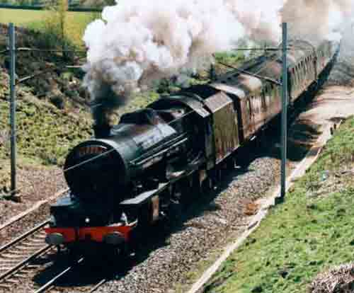
Fig 1 - Looking north
This northerly panorama of 6201 Princess Elizabeth descending past Greenholme in May 2002 was taken from just east of the minor road beween Greenholme and Roundthwaite. It shows a number of features mentioned elsewhere in these notes. Behind the train is Scotchmans Bridge. In front of the bridge an area of hard standing marks the Network Rail track access point. Beyond the bridge the line curves to Scout Green, marked by 3 distinct bushes in the left distance. Beyond the nearer line of trees on the right is the Westmoreland Hotel; Tebay Services are off-camera to the right.
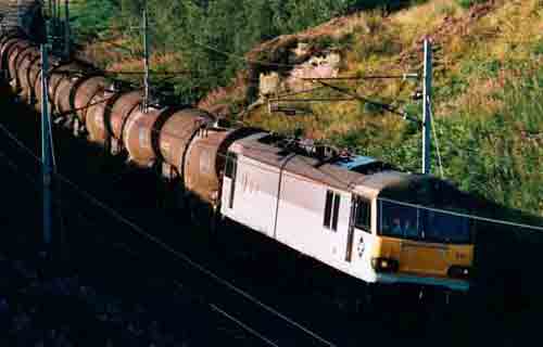
Fig 2 - Looking north
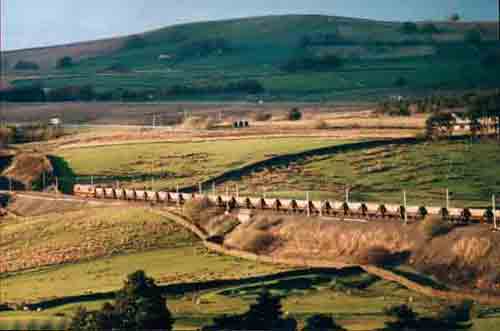
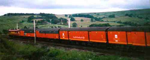
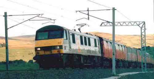
This north easterly view was also taken from the Greenholme-Roundthwaite road, at a point closer to Greenholme. The Class 66 is in roughly the same position as the last coach of 6201s train.
Fig 3 - Looking south east
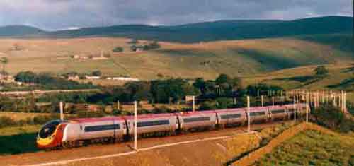
Another view towards the Greenholme embankment, but this time looking south east from the minor road between Scotchmans Bridge and Greenholme. The southbound Pendolino is heading away from the camera.
Fig 4 - Looking south west
A view to the south west from the footpath east of Scotchmans Bridge. This picture was taken at 21:46 in July.
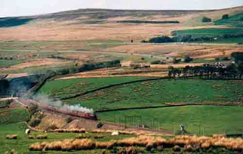
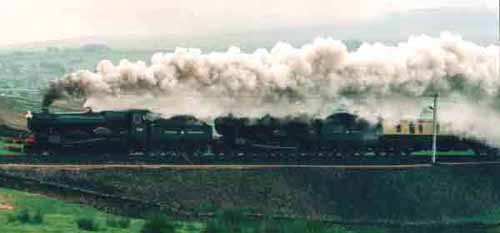
Fig 5 - Looking south
More steam action on the 1 in 75, taken from Scotchmans Bridge.
Fig 6 - Looking south
This 2003 picture looks south from the NR track access point just south of Scotchmans Bridge.
NB that additional gantries have been erected since 2002.
Fig 7 - Looking east
A close-up of steam action just south of the Network Rail track access point, taken from the Scotchmans Bridge-Greenholme road.
Fig 8 - Looking north
The northerly view from Scotchmans Bridge.
Disclaimer
All information contained within this is site is © Trainspots. The images used on this site remain the property of the original photographer, as credited at the top of the page, and are used with their kind permission.
The information on these pages is supplied for the benefit of railway enthusiasts who carry out a harmless hobby, and through the medium of photography and video, actually promote the railway industry. Railway enthusiasts can also act as eyes and ears against railway vandalism, and as such should surely be encouraged to do so by the supply of adequate information such as is found on this website.
This site has been created to assist railway photographers in their travels around the country. It is based on the personal knowledge and experience. No liability can be held against the web site or its contributions for incorrect information. Trainspots will endeavour to check all information and corrections will be accepted and posted accordingly.
Advice as to the locations general environment is given as a guide on each page. This information is a GUIDE only. ALWAYS be careful with your equipment, Trainspots can not be held responsible for your personal security. Avoid leaving your property on display for all to see, be aware of your surroundings at all times. There are, sadly, people who will not think twice about trying to steal your equipment.
Trainspots DOES NOT condone trespass and none of the information on this site should be taken as a right to trespass on either railway or private land. To the best of our knowledge all locations are publicly accessible areas, where they are not contact information will be given to the appropriate authority for permission to be obtained.
The content of this site is created and intended for all age ranges but the content of sites linked from this site are not subject to the same intentions. Trainspots will attempt to check links for validity but as time passes and the site grows this will not always be possible. Broken, or indeed updates to, links should be submitted to the editor for inclusion in the updates. All links external to the Trainspots site are opened in a new browser window. Trainspots has been running now for over 10 years and there are imitation sites and guides to railfotspots. But we are a free site and we continue on the path we started out on over a decade ago to provide a useful guide to UK Railway Photographic Locations.