New Mobile Site
We have just launched a new mobile version of this site - m.trainspots. This page will use your smart device's GPS to loctate you and guide you to locations that are close to your present location.
Location notes
Horbury Junction is located at the point where the Wakefield Kirkgate to Barnsley line diverges from the Wakefield Kirkgate to Huddersfield line, about 5 miles west of Wakefield.
Railway type and traffic
The main traffic on the line is Northern Rail DMUs consisting of Class 142, 144 , 150 and 158 providing hourly services from Wakefield to Huddersfield and frequent Leeds to Sheffield/Nottingham workings.
There are occasional freight workings, but only a handful during daylight hours. The busiest time for freight is between 12:00 and 14:00 when it might be possible to see two Freighliner Class 66 hauled binliners, the Preston Docks to Lindsey DBS Class 66 hauled empty bitumen tanks and possibly a Hunslet East to Tunstead DBS Class 66 empty cement tanks train.
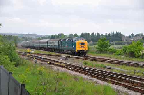
The line is also used by rail tours from the Crewe/Manchester/Preston areas heading towards York, Scarborough and Edinburgh and in the summer by Crewe to Scarborough steam excursions.
Because of the infrequency of loco hauled trains it is one of those locations where it is best to visit when you know in advance which workings are running.
There are occasional freight workings, but only a handful during daylight hours. The busiest time for freight is between 12:00 and 14:00 when it might be possible to see two Freighliner Class 66 hauled binliners, the Preston Docks to Lindsey DBS Class 66 hauled empty bitumen tanks and possibly a Hunslet East to Tunstead DBS Class 66 empty cement tanks train.
The line is also used by rail tours from the Crewe/Manchester/Preston areas heading towards York, Scarborough and Edinburgh and in the summer by Crewe to Scarborough steam excursions.
Because of the infrequency of loco hauled trains it is one of those locations where it is best to visit when you know in advance which workings are running.
Environment
Horbury Junction is in a quiet rural location about 5 minutes drive from Horbury Town Centre. The only people you are likely to meet are dog walkers or those out for a stroll around the nearby lagoon. You are unlikely to meet anyone when you are actually at the photo location as it is tucked out of the way. It is not regarded by locals as a problem area safety wise.
Road directions
Horbury Town Centre is about 5 minutes drive from M1 Junction 40. Head through Horbury and onto the A642 Horbury Bypass. Once on the bypass head westwards and then turn off at Daw Lane and then down Green Lane, both of which have clear street name signs. Follow Green Lane which becomes an unmarked road running alongside the railway line and drive right to the end up to the signal box just before the Motorway bridge. Park up and walk under the Motorway bridge and the turn right under the railway bridge. Immediately after the railway bridge climb up the embankment on the right through the wooden fence to reach the line side location. Please note that it could be muddy and you need to be fairly fit to do this.
Click here to set up your location for directions to this location
Horbury Junction, Wakefield, West Yorkshire map co-ordinates
Click here to set up your location for directions to this location
Horbury Junction, Wakefield, West Yorkshire map co-ordinates
Parking
There is ample (free) parking near the Signal Box or at the other side of the road. It is usually quite safe to leave your car there but as usual do not leave valuables in plain view and use a steering lock if you have one. The vehicle will be out of sight when you are at the location.
Public transport
It is difficult to reach this location on foot unless you are prepared to make a 20 - 30 minute walk from Horbury, where plenty of buses call either from Wakefield or Dewsbury. If so you would follow the same directions as above from Horbury town centre.
Click here to set up your location for directions to this location
Click here to set up your location for directions to this location
Amenities
There are no amenities in the area, the nearest shops, cafes, pubs etc are in Horbury.
Sun Compass
Sun Compass using Suncalc by brought to you by Vladimir Agafonkin:
It might be necessary to adjust the time to suit your visit, this link should open with the current day.
Horbury Junction, Wakefield, West Yorkshire
Streetmap links
Horbury Junction, Wakefield, West Yorkshire general view map
Horbury Junction, Wakefield, West Yorkshire close up map
Windows Local Live Link - image quality may vary
Horbury Junction, Wakefield, West Yorkshire
It might be necessary to adjust the time to suit your visit, this link should open with the current day.
Horbury Junction, Wakefield, West Yorkshire
Googly map
Horbury Junction, Wakefield, West Yorkshire general view map
Horbury Junction, Wakefield, West Yorkshire close up map
Windows Local Live Link - image quality may vary
Horbury Junction, Wakefield, West Yorkshire
Who likes this location on facebook
Railway Gen Group
Photographic notes
Photographs can be taken in both directions either from the line side railings and wooden fence or by climbing onto the concrete platform under the Motorway bridge for a raised view. A certain amount of agility is required for this as the concrete supports are about 5 foot high, so steps may be handy. In all cases this is away from the running lines and not a safety issue and not as dangerous as it sounds. The best shot to the west is achieved by walking along the concrete platform to avoid the shadows from the bridge. The sun is to the left until early afternoon and in the right position for photos. The only constraint on video shoots is the motorway noise.
An additional photographic option is to walk around the nearby Lagoon and take landscape shots from a distance. If you are interested in this there are plenty of options.You will need stout footwear as it can get muddy.
A further interesting shot is to climb part way up the steps on the motorway embankment opposite the signal box to get trains coming off the Barnsley line. Again there is no safety issue here providing that you keep well away from the motorway.
General views - All photographs © Neil Scarlett unless otherwise stated
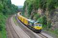
Fig 1 - Looking east
From under the motorway bridge.
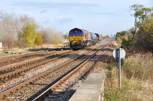
Fig 2 - Looking west
From under the motorway bridge, taken from the concrete bridge supports.
Fig 3 - Looking south west
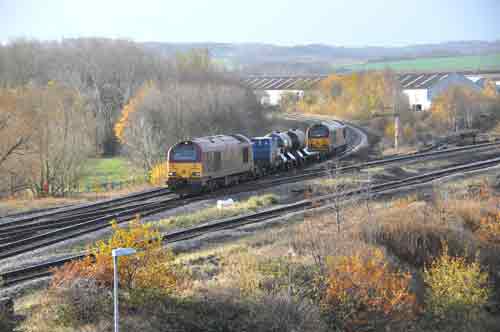
Taken from the motorway steps on the embankment a train rejoins from the Barnsey line.
Fig 4 - Looking north
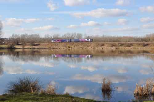
As viewed across Horbury Lagoon.
Disclaimer
All information contained within this is site is © Trainspots. The images used on this site remain the property of the original photographer, as credited at the top of the page, and are used with their kind permission.
The information on these pages is supplied for the benefit of railway enthusiasts who carry out a harmless hobby, and through the medium of photography and video, actually promote the railway industry. Railway enthusiasts can also act as eyes and ears against railway vandalism, and as such should surely be encouraged to do so by the supply of adequate information such as is found on this website.
This site has been created to assist railway photographers in their travels around the country. It is based on the personal knowledge and experience. No liability can be held against the web site or its contributions for incorrect information. Trainspots will endeavour to check all information and corrections will be accepted and posted accordingly.
Advice as to the locations general environment is given as a guide on each page. This information is a GUIDE only. ALWAYS be careful with your equipment, Trainspots can not be held responsible for your personal security. Avoid leaving your property on display for all to see, be aware of your surroundings at all times. There are, sadly, people who will not think twice about trying to steal your equipment.
Trainspots DOES NOT condone trespass and none of the information on this site should be taken as a right to trespass on either railway or private land. To the best of our knowledge all locations are publicly accessible areas, where they are not contact information will be given to the appropriate authority for permission to be obtained.
The content of this site is created and intended for all age ranges but the content of sites linked from this site are not subject to the same intentions. Trainspots will attempt to check links for validity but as time passes and the site grows this will not always be possible. Broken, or indeed updates to, links should be submitted to the editor for inclusion in the updates. All links external to the Trainspots site are opened in a new browser window. Trainspots has been running now for over 10 years and there are imitation sites and guides to railfotspots. But we are a free site and we continue on the path we started out on over a decade ago to provide a useful guide to UK Railway Photographic Locations.