New Mobile Site
We have just launched a new mobile version of this site - m.trainspots. This page will use your smart device's GPS to loctate you and guide you to locations that are close to your present location.
Location notes
An over bridge about ¼ mile east of Hope station.
Railway type and traffic
Regular passenger services are all worked by dmus, with Trans Pennine Class 185 or 158, and Central Trains Class 170 or 158, each running hourly on weekdays. In addition, there is a two hourly (hourly on Saturdays) local service, usually worked by Class 142 or 150, with an occasional Class 156.
There are a variety of freight trains, including stone trains from Peak Forest, Tunstead & Dowlow, cement trains from Earles Sidings, and occasional infrastructure trains to & from Castleton.
(But note that Corus has recently announced a plan to transfer production from Castleton to Scunthorpe).
There are a variety of freight trains, including stone trains from Peak Forest, Tunstead & Dowlow, cement trains from Earles Sidings, and occasional infrastructure trains to & from Castleton.
(But note that Corus has recently announced a plan to transfer production from Castleton to Scunthorpe).
Environment
A rural location about ¾ mile from Hope village.
Road directions
From the east, take the A6187 and turn right into Aston Lane.
From the south, use the B6049 via Tideswell, then turn left onto the A6187, and almost immediately turn right into Aston Lane.
From the Manchester area, use the A57 via Glossop to Ladybower Reservoir, then the A6013 to Bamford. Shortly after passing Bamford station, turn right onto the A6187 then as above.
From the west, access is difficult, the main road having been damaged by a landslip and not fully repaired.
From Chapel En Le Frith, travel via a series of minor roads, some steep and winding, and it is best to use an Ordnance Survey map to assist navigation.
Click here to set up your location for directions to this location
Hope, Parsons Lane Bridge map co-ordinates
Parking
There is probably space for 2 to 3 cars near the bridge, but note that the road serves a small industrial estate and farms, and wide vehicles use it occasionally. Parking at the station may be a safer alternative.
Public transport
By rail to the station by local services from Manchester Piccadilly or Sheffield. Leave the station on the south side of the footbridge, then turn left into a minor road, which passes next to a small factory. Turn left at the end of this road into Aston Lane.
Walking time about 5 minutes.
Click here to set up your location for directions to this location
Walking time about 5 minutes.
Click here to set up your location for directions to this location
Amenities
None. There are public toilets, shops and refreshments in Hope Village, on the A6187 about ¾ mile west of Aston Lane.
Sun Compass
Sun Compass using Suncalc by brought to you by Vladimir Agafonkin:
It might be necessary to adjust the time to suit your visit, this link should open with the current day.
Hope, Parsons Lane Bridge
Streetmap links
Hope, Parsons Lane Bridge general view map
Hope, Parsons Lane Bridge close up map
Windows Local Live Link - image quality may vary
Hope, Parsons Lane Bridge
It might be necessary to adjust the time to suit your visit, this link should open with the current day.
Hope, Parsons Lane Bridge
Googly map
Hope, Parsons Lane Bridge general view map
Hope, Parsons Lane Bridge close up map
Windows Local Live Link - image quality may vary
Hope, Parsons Lane Bridge
Who likes this location on facebook
Photographic notes
The sun is best placed for eastbound trains until early afternoon, and then for westbound trains until late afternoon. Note that from about October until March, when the sun is low in the sky, shade from trees can be a problem at most times of day.
General views - All photographs © Bevan Price unless otherwise stated
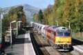
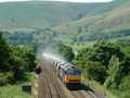
Fig 1 - Looking east
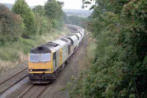
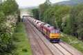
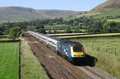
Fig 2 - Looking east
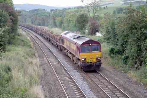
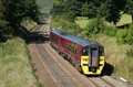
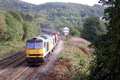
Fig 3 - Looking west
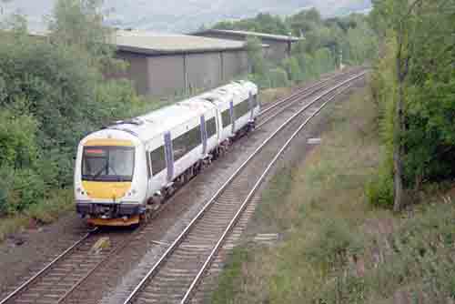
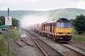
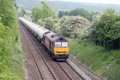
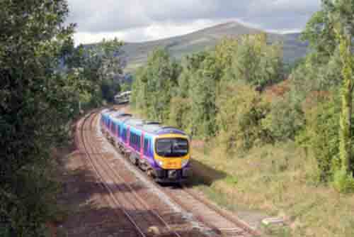
Fig 4 - Looking west
Disclaimer
All information contained within this is site is © Trainspots. The images used on this site remain the property of the original photographer, as credited at the top of the page, and are used with their kind permission.
The information on these pages is supplied for the benefit of railway enthusiasts who carry out a harmless hobby, and through the medium of photography and video, actually promote the railway industry. Railway enthusiasts can also act as eyes and ears against railway vandalism, and as such should surely be encouraged to do so by the supply of adequate information such as is found on this website.
This site has been created to assist railway photographers in their travels around the country. It is based on the personal knowledge and experience. No liability can be held against the web site or its contributions for incorrect information. Trainspots will endeavour to check all information and corrections will be accepted and posted accordingly.
Advice as to the locations general environment is given as a guide on each page. This information is a GUIDE only. ALWAYS be careful with your equipment, Trainspots can not be held responsible for your personal security. Avoid leaving your property on display for all to see, be aware of your surroundings at all times. There are, sadly, people who will not think twice about trying to steal your equipment.
Trainspots DOES NOT condone trespass and none of the information on this site should be taken as a right to trespass on either railway or private land. To the best of our knowledge all locations are publicly accessible areas, where they are not contact information will be given to the appropriate authority for permission to be obtained.
The content of this site is created and intended for all age ranges but the content of sites linked from this site are not subject to the same intentions. Trainspots will attempt to check links for validity but as time passes and the site grows this will not always be possible. Broken, or indeed updates to, links should be submitted to the editor for inclusion in the updates. All links external to the Trainspots site are opened in a new browser window. Trainspots has been running now for over 10 years and there are imitation sites and guides to railfotspots. But we are a free site and we continue on the path we started out on over a decade ago to provide a useful guide to UK Railway Photographic Locations.