New Mobile Site
We have just launched a new mobile version of this site - m.trainspots. This page will use your smart device's GPS to loctate you and guide you to locations that are close to your present location.
Location notes
Shustoke is about halfway on the Birmingham-Nuneaton line.
Railway type and traffic
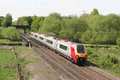
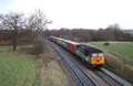
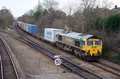
Local 'Central' units can be seen on the line, as can various freight workings, mainly DB Schenker and Freightliner.
Environment
This is a quiet location in the countryside.
Road directions
From the M42, Junction 9:
Head south on the A446 until you reach the first roundabout. Turn left here into the dual carriageway (Faraday Lane) and take the first left which will take you to Lea Marston.
From here, head Eastwards which will bring you to Whitacre Heath. When you reach the main road, turn right, and follow this road until you need a left hand turn to Hogrills End. Take this turning, and follow the road bearing right down Hogrills End Lane when you reach the small junction. Just after this road bears left, you should notice Lansdown House to your right. Keep going, and you will then pass another farm building on your right, and there is a left hand turning, but keep going until you get to a couple of houses on your left. You can park here (without blocking there drives) and you should notice the public footpath on the other side of the road. This leads down to the location.
Click here to set up your location for directions to this location
Shustoke Reservoir, Crossing #2 map co-ordinates
Parking
You can park your vehicle safely at the side of the road.
Alternatively, you can park in the car park which is accessible from the south of the reservoir. All Shustoke locations are linked by the same footpath, but it is easier to get to the single locations as described in their 'individual' road directions.
Alternatively, you can park in the car park which is accessible from the south of the reservoir. All Shustoke locations are linked by the same footpath, but it is easier to get to the single locations as described in their 'individual' road directions.
Public transport
Amenities
There are at least a couple of pubs in nearby Whitacre Heath. Also nearby is Water Orton which has many shops that should provide for most needs.
Accommodation
You could always try the Railway Guest House in Whitacre Heath. There is also a large hotel just to the North of Lea Marston, which is situated off of Haunch lane.
Sun Compass
Sun Compass using Suncalc by brought to you by Vladimir Agafonkin:
It might be necessary to adjust the time to suit your visit, this link should open with the current day.
Shustoke Reservoir, Crossing #2
Streetmap links
Shustoke Reservoir, Crossing #2 general view map
Shustoke Reservoir, Crossing #2 close up map
Windows Local Live Link - image quality may vary
Shustoke Reservoir, Crossing #2
It might be necessary to adjust the time to suit your visit, this link should open with the current day.
Shustoke Reservoir, Crossing #2
Googly map
Shustoke Reservoir, Crossing #2 general view map
Shustoke Reservoir, Crossing #2 close up map
Windows Local Live Link - image quality may vary
Shustoke Reservoir, Crossing #2
Who likes this location on facebook
Railway Gen Group
Photographic notes
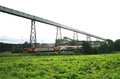
NoteThis location isn`t actually a crossing, but an underpass. Once under the railway, there are some steps which bring you back up to a decent height to take photographs.
Photos are only really possible from the south of the line, but can be had in both directions. Shadows from the trees can be troublesome at certain times of the year, so mid-summer is generally the best time of year here.
Photos are only really possible from the south of the line, but can be had in both directions. Shadows from the trees can be troublesome at certain times of the year, so mid-summer is generally the best time of year here.
General views - All photographs © Jason Rodhouse unless otherwise stated
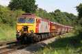
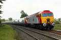
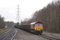
Fig 1 - Looking west
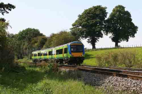
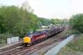
Fig 2 - Looking west
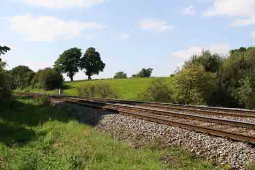
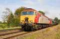
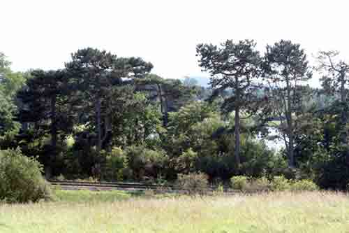
Fig 3 - Looking east
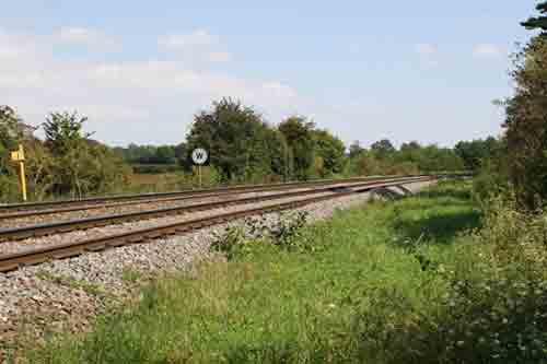
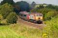
Fig 4 - Looking south
From the road
Disclaimer
All information contained within this is site is © Trainspots. The images used on this site remain the property of the original photographer, as credited at the top of the page, and are used with their kind permission.
The information on these pages is supplied for the benefit of railway enthusiasts who carry out a harmless hobby, and through the medium of photography and video, actually promote the railway industry. Railway enthusiasts can also act as eyes and ears against railway vandalism, and as such should surely be encouraged to do so by the supply of adequate information such as is found on this website.
This site has been created to assist railway photographers in their travels around the country. It is based on the personal knowledge and experience. No liability can be held against the web site or its contributions for incorrect information. Trainspots will endeavour to check all information and corrections will be accepted and posted accordingly.
Advice as to the locations general environment is given as a guide on each page. This information is a GUIDE only. ALWAYS be careful with your equipment, Trainspots can not be held responsible for your personal security. Avoid leaving your property on display for all to see, be aware of your surroundings at all times. There are, sadly, people who will not think twice about trying to steal your equipment.
Trainspots DOES NOT condone trespass and none of the information on this site should be taken as a right to trespass on either railway or private land. To the best of our knowledge all locations are publicly accessible areas, where they are not contact information will be given to the appropriate authority for permission to be obtained.
The content of this site is created and intended for all age ranges but the content of sites linked from this site are not subject to the same intentions. Trainspots will attempt to check links for validity but as time passes and the site grows this will not always be possible. Broken, or indeed updates to, links should be submitted to the editor for inclusion in the updates. All links external to the Trainspots site are opened in a new browser window. Trainspots has been running now for over 10 years and there are imitation sites and guides to railfotspots. But we are a free site and we continue on the path we started out on over a decade ago to provide a useful guide to UK Railway Photographic Locations.