New Mobile Site
We have just launched a new mobile version of this site - m.trainspots. This page will use your smart device's GPS to loctate you and guide you to locations that are close to your present location.
Location notes
Daw Mill is a colliery on the Nuneaton-Birmingham line, roughly in the middle of that line.
Railway type and traffic
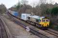
Local 'Central' units can be seen on the line, as can various freight workings, mainly DB Schenker and Freightliner. This can also be a diversion route for the West Coast when the Coventry line is shut, with the electric trains being dragged with class 57 locomotives.
Environment
This location is a field next to the line and on the opposite side of the colliery. The field entrance can be very wet and boggy, and the field can also be wet in places.
Road directions
From Nuneaton take either the B4114 or B4112 in the west direction; the B4112 joins the B4114 at Ansley. Follow the B4114 until you come down a hill and it joins the B4098 where you want to turn left and then take the next right, past the entrance to the colliery. The junction of these two roads is an alternative parking location mentioned below. Follow this road down under the railway and you will see the field entrance on the right.
From the M6, Junction 4:
Take the third exit at the roundabout onto the A446 towards Coleshill. Continue straight at the next roundabout and then exit right (crossing the other carriageway), and drive into Coleshill itself, this is the B4117. In the middle of Coleshill, at the crossroads, take the right exit up the hill and past the church, this is the B4114 and will be signposted Shustoke. Follow this road passed the reservoirs and over the railway until you reach Furnace End. Here at the crossroads take the right hand exit onto the B4098 and pass through the village of Over Whitacre, down the hill pass the junction with the B4114 (again!), and then its the next right, past the entrance to the colliery. The junction of these two roads is an alternative parking location mentioned below. Follow this road down under the railway and you will see the field entrance on the right.
Click here to set up your location for directions to this location
Daw Mill map co-ordinates
Parking
Parking is available at the field entrance, but this can be very wet even in the driest of weather. Also make sure you do not block both the field entrances and the small road, which is used by large farm equipment. If all else fails it is possible to park on the hard standing at the junction of the B4098 and Daw Mill lane.
Once parked, follow the footpath through the field to the left until it reaches a small tunnel way under the line. Do not go under the line but head off towards the left up the hill. Once at the top of the small hill you should be able to see the shot.
Once parked, follow the footpath through the field to the left until it reaches a small tunnel way under the line. Do not go under the line but head off towards the left up the hill. Once at the top of the small hill you should be able to see the shot.
Public transport
Stagecoach service 717 operates hourly between Nuneaton and Birmingham International and passes along the B4114 between Furnace End, Church End and Shustoke.
Click here to set up your location for directions to this location
Click here to set up your location for directions to this location
Amenities
There are no amenities at the location, with the nearest town being Nuneaton or Whitarce.
Sun Compass
Sun Compass using Suncalc by brought to you by Vladimir Agafonkin:
It might be necessary to adjust the time to suit your visit, this link should open with the current day.
Daw Mill
Streetmap links
Daw Mill general view map
Daw Mill close up map
Windows Local Live Link - image quality may vary
Daw Mill
It might be necessary to adjust the time to suit your visit, this link should open with the current day.
Daw Mill
Googly map
Daw Mill general view map
Daw Mill close up map
Windows Local Live Link - image quality may vary
Daw Mill
Who likes this location on facebook
Railway Gen Group
Photographic notes
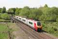
The line runs roughly north-west to south-east at this point, but due to the slight cutting and vegetation at this location the favoured shot is of lunch time eastbound trains. This can be taken with a variety of focal lengths from around 200mm to 300mm. Steps are required to gain that little bit of extra height to get the whole train in.
General views - All photographs © Richard Tearle unless otherwise stated
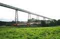
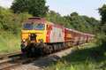
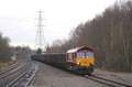
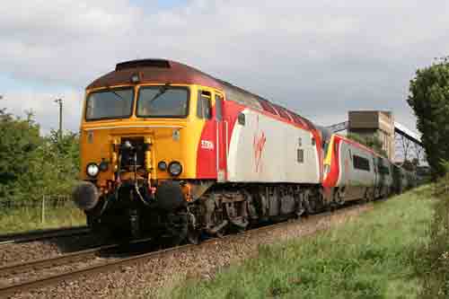
Fig 1 - Looking west
Taken from the highest point in the field on a small set of steps from the south side of the line with an eastbound train on a bright summer lunchtime, with a 200mm lens.
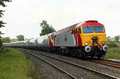
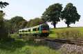
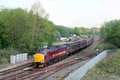
Fig 2 - Looking west - Image © Jason Rodhouse
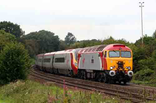
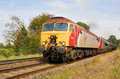
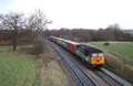
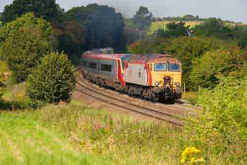
Fig 3 - Looking east - Image © Jason Rodhouse
Disclaimer
All information contained within this is site is © Trainspots. The images used on this site remain the property of the original photographer, as credited at the top of the page, and are used with their kind permission.
The information on these pages is supplied for the benefit of railway enthusiasts who carry out a harmless hobby, and through the medium of photography and video, actually promote the railway industry. Railway enthusiasts can also act as eyes and ears against railway vandalism, and as such should surely be encouraged to do so by the supply of adequate information such as is found on this website.
This site has been created to assist railway photographers in their travels around the country. It is based on the personal knowledge and experience. No liability can be held against the web site or its contributions for incorrect information. Trainspots will endeavour to check all information and corrections will be accepted and posted accordingly.
Advice as to the locations general environment is given as a guide on each page. This information is a GUIDE only. ALWAYS be careful with your equipment, Trainspots can not be held responsible for your personal security. Avoid leaving your property on display for all to see, be aware of your surroundings at all times. There are, sadly, people who will not think twice about trying to steal your equipment.
Trainspots DOES NOT condone trespass and none of the information on this site should be taken as a right to trespass on either railway or private land. To the best of our knowledge all locations are publicly accessible areas, where they are not contact information will be given to the appropriate authority for permission to be obtained.
The content of this site is created and intended for all age ranges but the content of sites linked from this site are not subject to the same intentions. Trainspots will attempt to check links for validity but as time passes and the site grows this will not always be possible. Broken, or indeed updates to, links should be submitted to the editor for inclusion in the updates. All links external to the Trainspots site are opened in a new browser window. Trainspots has been running now for over 10 years and there are imitation sites and guides to railfotspots. But we are a free site and we continue on the path we started out on over a decade ago to provide a useful guide to UK Railway Photographic Locations.