New Mobile Site
We have just launched a new mobile version of this site - m.trainspots. This page will use your smart device's GPS to loctate you and guide you to locations that are close to your present location.
Location notes
The Queensville Curve is immediately south of Stafford station on the West Coast Main Line, and is where the Trent Valley route turns through ninety degrees to head briefly east away from the Birmingham line.
Railway type and traffic
The main services on the line are the now Pendolino operated Liverpool and Preston/Glasgow to London Euston services, with Holyhead to London trains operated by Voyagers. There is an hourly Stafford to Birmingham via Walsall local service.
Freight at this point is mainly Freightliner and DB Schenker Enterprise services heading south out of Crewe.
Freight at this point is mainly Freightliner and DB Schenker Enterprise services heading south out of Crewe.
Environment
The footbridge is fairly quiet, with houses and the large Alstom Electrical Works to the north, with a field to the south and the path leading to another small estate.
Road directions
From the M6, Junction 13:
Head north along the A449 towards Stafford. The road crosses the Stafford to Birmingham line as it enters the start of the built up area. After another mile or so, the road crosses the main line. Take the next road on the right and park towards the end of this residential road.
Turn right at the end towards the railway, taking the footpath on the left alongside it to the footbridge.
Click here to set up your location for directions to this location
Stafford, Queensville Curve map co-ordinates
Parking
As mentioned above, park on the residential roads near to the location.
Public transport
From Stafford Station, turn right outside to the traffic lights. Turn left, and take the first road on the right after passing Tesco's. Follow this road, passing the 'Bear and Pheasant' Pub, to it's end, and turn right onto the main road - there is a bright yellow pub, 'The Telegraph Inn', on the right. Arriva service 8 operates along this road from Stafford Town Centre to Moss Pit (another Trainspot). Turn left before the road crosses the railway and keep alongside the railway on the road, then on a footpath, until you reach the footbridge.
Click here to set up your location for directions to this location
Click here to set up your location for directions to this location
Amenities
There are no amenities close to the bridge. There are several pubs in the Stafford area. out of the two already mentioned, the Bear and Pheasant is the better, though the 'Titanic' outside Stafford Station is a good real ale pub. There is an Off-Licence on the main road near the Telegraph Inn.
Sun Compass
Sun Compass using Suncalc by brought to you by Vladimir Agafonkin:
It might be necessary to adjust the time to suit your visit, this link should open with the current day.
Stafford, Queensville Curve
Streetmap links
Stafford, Queensville Curve general view map
Stafford, Queensville Curve close up map
Windows Local Live Link - image quality may vary
Stafford, Queensville Curve
It might be necessary to adjust the time to suit your visit, this link should open with the current day.
Stafford, Queensville Curve
Googly map
Stafford, Queensville Curve general view map
Stafford, Queensville Curve close up map
Windows Local Live Link - image quality may vary
Stafford, Queensville Curve
Who likes this location on facebook
Railway Gen Group
Photographic notes
The light is best from mid-morning for southbound trains through to early evening for northbound ones. The curve of the line is the wrong way for ideal photos, but it does mean that mid-afternoon, the light is right for trains in both directions. Only trains on the Down Slow are slightly constricted for photographing.
General views - All photographs © Mark Bearton unless otherwise stated
Fig 1 - Looking north
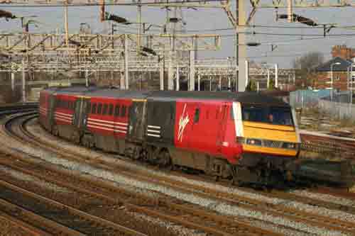
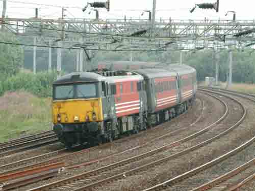
Fig 2 - Looking south
Disclaimer
All information contained within this is site is © Trainspots. The images used on this site remain the property of the original photographer, as credited at the top of the page, and are used with their kind permission.
The information on these pages is supplied for the benefit of railway enthusiasts who carry out a harmless hobby, and through the medium of photography and video, actually promote the railway industry. Railway enthusiasts can also act as eyes and ears against railway vandalism, and as such should surely be encouraged to do so by the supply of adequate information such as is found on this website.
This site has been created to assist railway photographers in their travels around the country. It is based on the personal knowledge and experience. No liability can be held against the web site or its contributions for incorrect information. Trainspots will endeavour to check all information and corrections will be accepted and posted accordingly.
Advice as to the locations general environment is given as a guide on each page. This information is a GUIDE only. ALWAYS be careful with your equipment, Trainspots can not be held responsible for your personal security. Avoid leaving your property on display for all to see, be aware of your surroundings at all times. There are, sadly, people who will not think twice about trying to steal your equipment.
Trainspots DOES NOT condone trespass and none of the information on this site should be taken as a right to trespass on either railway or private land. To the best of our knowledge all locations are publicly accessible areas, where they are not contact information will be given to the appropriate authority for permission to be obtained.
The content of this site is created and intended for all age ranges but the content of sites linked from this site are not subject to the same intentions. Trainspots will attempt to check links for validity but as time passes and the site grows this will not always be possible. Broken, or indeed updates to, links should be submitted to the editor for inclusion in the updates. All links external to the Trainspots site are opened in a new browser window. Trainspots has been running now for over 10 years and there are imitation sites and guides to railfotspots. But we are a free site and we continue on the path we started out on over a decade ago to provide a useful guide to UK Railway Photographic Locations.