New Mobile Site
We have just launched a new mobile version of this site - m.trainspots. This page will use your smart device's GPS to loctate you and guide you to locations that are close to your present location.
Location notes
Network Rail have closed this foot crossing making the location unavailable.
Moss Pit is a residential area at the southern tip of Stafford and is on the line from Stafford towards Wolverhampton and Birmingham.
Moss Pit is a residential area at the southern tip of Stafford and is on the line from Stafford towards Wolverhampton and Birmingham.
Railway type and traffic
There is a regular passenger service on the line of Voyagers on longer distance services and various units on the Birmingham to Liverpool services.
Freight comprises of services south of Crewe generally to the South Coast, also Infrastructure trains from Basford Hall to Bescot. West Coast services are sometimes diverted this way on weekends.
Freight comprises of services south of Crewe generally to the South Coast, also Infrastructure trains from Basford Hall to Bescot. West Coast services are sometimes diverted this way on weekends.
Environment
The foot crossing is little used and separates a quiet residential area from open fields.
Road directions
From the M6, Junction 13:
Head north along the A449 towards Stafford. The road crosses the Stafford to Birmingham line as it enters the start of the built up area.
Turn right immediately after the bridge and the foot crossing is facing you as the road turns parallel to the line.
Click here to set up your location for directions to this location
Stafford, Moss Pit map co-ordinates
Parking
You can park on the road by the crossing.
Public transport
Arriva service 8 operates every 12 minutes from Stafford town centre to Moss Pit. It operates around the estate (Burton Bank Lane) then you need to alight once it turns back onto the main A449 to return to town.
Arriva services 75 and 76 operate along the main road (A449) every 30 minutes between Stafford and Penkridge, with the 76 hourly extending to Wolverhampton.
Click here to set up your location for directions to this location
Arriva services 75 and 76 operate along the main road (A449) every 30 minutes between Stafford and Penkridge, with the 76 hourly extending to Wolverhampton.
Click here to set up your location for directions to this location
Amenities
There are no shops or pubs near this location. The Garth Hotel has a bar and serves food at dinner and tea/evening.
Sun Compass
Sun Compass using Suncalc by brought to you by Vladimir Agafonkin:
It might be necessary to adjust the time to suit your visit, this link should open with the current day.
Stafford, Moss Pit
Streetmap links
Stafford, Moss Pit general view map
Stafford, Moss Pit close up map
Windows Local Live Link - image quality may vary
Stafford, Moss Pit
It might be necessary to adjust the time to suit your visit, this link should open with the current day.
Stafford, Moss Pit
Googly map
Stafford, Moss Pit general view map
Stafford, Moss Pit close up map
Windows Local Live Link - image quality may vary
Stafford, Moss Pit
Who likes this location on facebook
Railway Gen Group
Photographic notes
Network Rail have closed this foot crossing making the location unavailable.
The light is best for southbound (from Stafford) trains from about 1pm, or for the rear of northbound units before. The sun is head-on at roughly 12.30. There is a bridge immediately to the south carrying the A449 over the railway, though shots in this direction are only really possible on cloudy days. To the south the line is straight for about 4 miles to Penkridge, so there is plenty of warning of approaching trains, to the north, the line is only straight to School Lane bridge, though trains are accelerating away from Stafford so rarely at full speed.
The light is best for southbound (from Stafford) trains from about 1pm, or for the rear of northbound units before. The sun is head-on at roughly 12.30. There is a bridge immediately to the south carrying the A449 over the railway, though shots in this direction are only really possible on cloudy days. To the south the line is straight for about 4 miles to Penkridge, so there is plenty of warning of approaching trains, to the north, the line is only straight to School Lane bridge, though trains are accelerating away from Stafford so rarely at full speed.
General views - All photographs © Mark Bearton unless otherwise stated
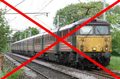
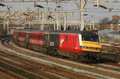
Fig 1 - Looking north
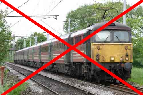
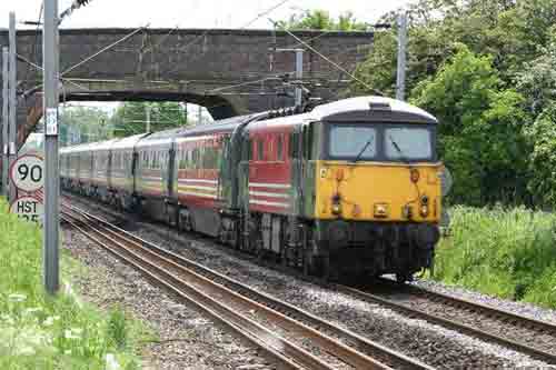
Fig 2 - Looking north
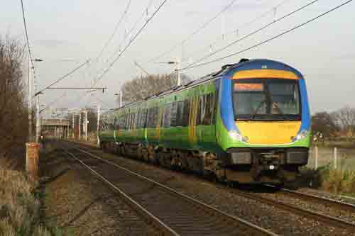
Fig 3 - Looking north
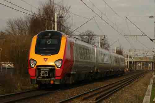
Fig 4 - Looking south
Disclaimer
All information contained within this is site is © Trainspots. The images used on this site remain the property of the original photographer, as credited at the top of the page, and are used with their kind permission.
The information on these pages is supplied for the benefit of railway enthusiasts who carry out a harmless hobby, and through the medium of photography and video, actually promote the railway industry. Railway enthusiasts can also act as eyes and ears against railway vandalism, and as such should surely be encouraged to do so by the supply of adequate information such as is found on this website.
This site has been created to assist railway photographers in their travels around the country. It is based on the personal knowledge and experience. No liability can be held against the web site or its contributions for incorrect information. Trainspots will endeavour to check all information and corrections will be accepted and posted accordingly.
Advice as to the locations general environment is given as a guide on each page. This information is a GUIDE only. ALWAYS be careful with your equipment, Trainspots can not be held responsible for your personal security. Avoid leaving your property on display for all to see, be aware of your surroundings at all times. There are, sadly, people who will not think twice about trying to steal your equipment.
Trainspots DOES NOT condone trespass and none of the information on this site should be taken as a right to trespass on either railway or private land. To the best of our knowledge all locations are publicly accessible areas, where they are not contact information will be given to the appropriate authority for permission to be obtained.
The content of this site is created and intended for all age ranges but the content of sites linked from this site are not subject to the same intentions. Trainspots will attempt to check links for validity but as time passes and the site grows this will not always be possible. Broken, or indeed updates to, links should be submitted to the editor for inclusion in the updates. All links external to the Trainspots site are opened in a new browser window. Trainspots has been running now for over 10 years and there are imitation sites and guides to railfotspots. But we are a free site and we continue on the path we started out on over a decade ago to provide a useful guide to UK Railway Photographic Locations.