New Mobile Site
We have just launched a new mobile version of this site - m.trainspots. This page will use your smart device's GPS to loctate you and guide you to locations that are close to your present location.
Location notes
On the ECML, this level crossing is approximately 8 miles south of Peterborough and is just over a mile south of Holme level crossing. The nearest city is Peterborough, however there are several villages in the area.
Railway type and traffic
Being on the main line between Peterborough and London King's Cross, traffic is plentiful yet standardised.
Expect to see East Coast HSTs, 225 sets; First Capital Connect services are operated by a mixture of Class 317 and Class 365 units. The odd daytime freight working also passes through here, including the Biggleswade Plasmor flow.
Expect to see East Coast HSTs, 225 sets; First Capital Connect services are operated by a mixture of Class 317 and Class 365 units. The odd daytime freight working also passes through here, including the Biggleswade Plasmor flow.
Environment
The location is at the start of a small farm road and is on the edge of open fields. A minor road does lie quite close to the crossing and traffic is light; in terms of the crossing itself, traffic is very light, with the occasional car and lorry heading down to the farm.
Road directions
From the North
Exit the A1(M) at junction 15 (Sawtry) to gain access to the B1043. Head north and then turn right at Conington (probably signposted). Go through the village and then turn right. Now simply stay on this road until you get to the level crossing.
From the South
Exit the A1(M) at Sawtry and then at the roundabout, take the third exit. Stay on this road until you get to a roundabout in the village and then take the third exit - this will lead you over the A1(M) and up to a roundabout. Now take the first exit to access the B1043 and then head north. Turn right at Conington (probably signposted), go through the village and then turn right. Now simply stay on this road until you get to the level crossing.
Heading from Ramsey St Mary (on the B660), go over Holme level crossing and take the first left (signposted 'Conington'). A bit further down this road, take the first left and you will be on a narrow road which will sweep around and bring you parallel to the railway. Go to the end of this road and then take the left turn.
Click here to set up your location for directions to this location
Conington North Level Crossing map co-ordinates
Parking
There is a small area in which to park, however this is in the entrance to a maintenance access area. Therefore, if maintenance workers turn up, you should be prepared to move your car, perhaps to the other side of the crossing. The parking bit is very close to the crossing.
Public transport
Bus routes 352 (Peterborough - Conington) and 415 (Wood Walton - Peterborough) both operate through Holme, so it would be feasible to get off there and walk to the crossing but it would be quite a hike if you have a lot of equipment to carry.
Click here to set up your location for directions to this location
Click here to set up your location for directions to this location
Amenities
Unfortunately there are no facilities in the area itself. There are a couple of chip shops in Yaxley (about 3 miles away) and there is also a Little Chef in Sawtry (4 miles away). Most amenities will, of course, be in Peterborough which is within easy travelling distance for lunch and supplies.
Accommodation
There are a couple of hotels in nearby Stilton, with a Holiday Inn at Norman Cross.
Sun Compass
Sun Compass using Suncalc by brought to you by Vladimir Agafonkin:
It might be necessary to adjust the time to suit your visit, this link should open with the current day.
Conington North Level Crossing
Streetmap links
Conington North Level Crossing general view map
Conington North Level Crossing close up map
Windows Local Live Link - image quality may vary
Conington North Level Crossing
It might be necessary to adjust the time to suit your visit, this link should open with the current day.
Conington North Level Crossing
Googly map
Conington North Level Crossing general view map
Conington North Level Crossing close up map
Windows Local Live Link - image quality may vary
Conington North Level Crossing
Who likes this location on facebook
Railway Gen Group
Photographic notes
Being a level crossing there are options for views of either the up close and personal or of the side on three quater views available from this location.
CONINGTON SIDE:
Looking in the up direction, visibility is obscured by a shed, however a telephoto lens could possibly produce reasonable shots. In the down direction, visibility is much better, with the OLE nicely out of the way. Good shots are possibly looking north from the crossing itself, and there is also a small bridge beside where you might have parked your car that produces good opportunities.
RAMSAY ST MARY SIDE:
Again, the up direction isn't too fruitful, however it is possible to go up to the fence beside the crossing and get some reasonable shots of the trains.
Looking in the down direction, some good shots are possible however you must be ready as the trains (the GNERs especially) suddenly appear from behind the trees thus leaving little time to release the shutter.
One crucial point is that the crossing utilises full width barriers, thus meaning that you must be sure of where you want to take your photos; you could potentially get stuck on one side and should you want to take up and down trains from different sides of the crossing, then you can't.
As the line runs North-South, the sun is not a major problem, but it is worth visiting the crossing to familiarise yourself with which side of the crossing you prefer.
General views - All photographs © Allan Stevens unless otherwise stated
Fig 1 - Looking south - Image © Brian Carter
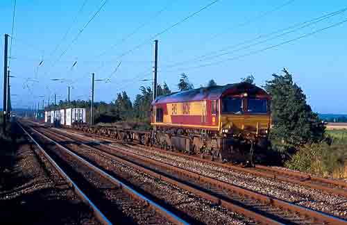
Taken at about 7am, featuring a diverted freight on the slow line.
You need stepladders, and place them in the middle of the road right next to the lowered barrier (on the east side of the crossing) - but you get plenty of warning of approaching trains since the crossing is not automatic.
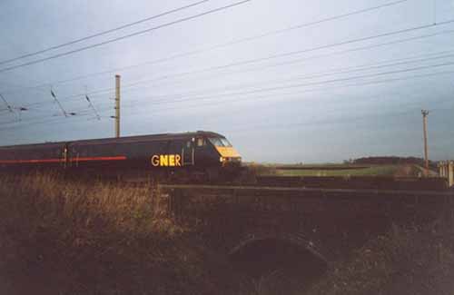
Fig 2 - Looking north
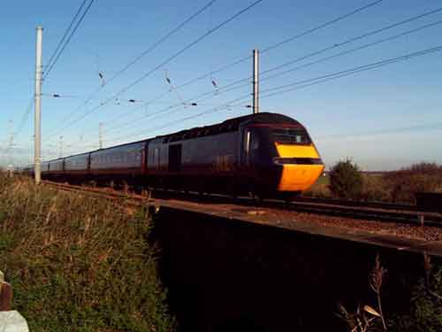
Fig 3 - Looking north
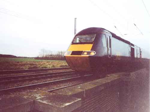
Fig 4 - Looking south
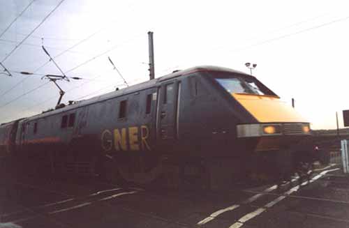
Fig 5 - From the bridge
Disclaimer
All information contained within this is site is © Trainspots. The images used on this site remain the property of the original photographer, as credited at the top of the page, and are used with their kind permission.
The information on these pages is supplied for the benefit of railway enthusiasts who carry out a harmless hobby, and through the medium of photography and video, actually promote the railway industry. Railway enthusiasts can also act as eyes and ears against railway vandalism, and as such should surely be encouraged to do so by the supply of adequate information such as is found on this website.
This site has been created to assist railway photographers in their travels around the country. It is based on the personal knowledge and experience. No liability can be held against the web site or its contributions for incorrect information. Trainspots will endeavour to check all information and corrections will be accepted and posted accordingly.
Advice as to the locations general environment is given as a guide on each page. This information is a GUIDE only. ALWAYS be careful with your equipment, Trainspots can not be held responsible for your personal security. Avoid leaving your property on display for all to see, be aware of your surroundings at all times. There are, sadly, people who will not think twice about trying to steal your equipment.
Trainspots DOES NOT condone trespass and none of the information on this site should be taken as a right to trespass on either railway or private land. To the best of our knowledge all locations are publicly accessible areas, where they are not contact information will be given to the appropriate authority for permission to be obtained.
The content of this site is created and intended for all age ranges but the content of sites linked from this site are not subject to the same intentions. Trainspots will attempt to check links for validity but as time passes and the site grows this will not always be possible. Broken, or indeed updates to, links should be submitted to the editor for inclusion in the updates. All links external to the Trainspots site are opened in a new browser window. Trainspots has been running now for over 10 years and there are imitation sites and guides to railfotspots. But we are a free site and we continue on the path we started out on over a decade ago to provide a useful guide to UK Railway Photographic Locations.


