New Mobile Site
We have just launched a new mobile version of this site - m.trainspots. This page will use your smart device's GPS to loctate you and guide you to locations that are close to your present location.
Location notes
Located on the site of a former level crossing (now closed) just North of Werrington Junction, Peterborough. It is on the main ECML running between Peterborough and Grantham, plus the Peterborough to Stamford line. The Peterborough to Spalding line can also be seen from the footbridge.
Railway type and traffic
Passenger traffic consists mainly of East Coast operated 91s and HSTs for East Coast services.
Other operators workings include Grand Central HSTs and 180s.
First Hull Trains runn 180's on their services.
EMT trains on the Spalding branch are worked mainly by 153s, with 156s and 158s on busier workings.
EMT Norwich - Liverpool services are worked by 158s - very occasionally 156s.
Arriva Cross Country Birmingham - Stanstead Airport services are worked by 170s.
The NMT makes regular runs between Heaton and Bounds Green(usually Mondays)and there are regular Serco trips between Derby and East Anglia(37s and 31s), and the line is very popular with charter trains(47s, 90s and 67s)on Saturdays in particular.
Freightliner 66s work modal and aggregates only.
99% of DB Schenker workings are 66 hauled. Best chance of getting a class 60 is on the Ely - Peak Forest working, followed by occasional trips out to the Anglia region on aggregate workings from Mountsorrel or engineers trips from Toton - usually after overhaul or reinstatement.
There is 1 daylight (March - October)class 92 working (Dollands Moor - Scunthorpe) viewable in the late evening.
Environment
Narrow dead end road in the countryside near some cottages, stables and a farm. No lighting, so not suitable after sun down. There are shots to be had from the footbridge in both directions, as well as alongside the track from the adjacent field/footpath and base of the footbridge. If it rains you can sit in your car and still see the trains, although you will not see the Spalding line.
Road directions
From the A47 take the Junction for Castor and Ailsworth.
From the Leicester direction head into and through the village of Castor and head back over the A47 before turning left at the Marholm turn.
From the Peterborough direction take the slip road for Castor and at the end turn right over the A47 then immediatley left(the Marholm turn).
Just follow this road until you reach a Give Way in the next village(Marholm)with a crossroads where you will go straight over. Then just follow this twisty road, over a narrow bridge, all the way heading straight on - do not take the turn to the left!
There is access from the A15 to the north side of the former crossing, but this is only to access the cottages where it is not so easy to park without obstructing things.
Click here to set up your location for directions to this location
Marholm map co-ordinates
Parking
Park to the side of the road near the base of the footbridge. Usually plenty of room (although busier when there is something special on!), but be courteous to the people looking after the horses and the farm workers on the Castor side, and the people living in the cottages on the A15 side.
Public transport
The nearest bus route would be Werrington, but still quite a walk. There are buses passing nearby on the A15, but not sure where the stop is - try Peterborough Bus Times for some more information.
If you have a bike though the footbridge is on 'The Green Wheel' cycle route and has ramps to allow you to easily get across the bridge.
Click here to set up your location for directions to this location
If you have a bike though the footbridge is on 'The Green Wheel' cycle route and has ramps to allow you to easily get across the bridge.
Click here to set up your location for directions to this location
Amenities
There is a pub in Marholm. Nearest shops would be in Werrington/Bretton, and Peterborough centre itself is only about 10 minutes away by car.
Sun Compass
Sun Compass using Suncalc by brought to you by Vladimir Agafonkin:
It might be necessary to adjust the time to suit your visit, this link should open with the current day.
Marholm
Streetmap links
Marholm general view map
Marholm close up map
Windows Local Live Link - image quality may vary
Marholm
It might be necessary to adjust the time to suit your visit, this link should open with the current day.
Marholm
Googly map
Marholm general view map
Marholm close up map
Windows Local Live Link - image quality may vary
Marholm
Who likes this location on facebook
Railway Gen Group
Photographic notes
The fact you can move either side of the bridge allows for some form of shot throughout the day, but Southbound shots are possible pretty much all day, while Northbound shots are best from afternoon onwards. The low sun can be a problem for morning Northbound Autumn/Winter shots. You can get a shot of the Spalding line from the footbridge, but it is not very good. You can see the line for around a mile or more in both directions, so if you have a telephoto lens that opens up some more possibilities.
It is worth bearing in mind though that the ECML expresses will be doing in excess of 100mph. There is hardly any noise for videoing apart from the A15 when the wind is in that direction - plus the occasional Harrier from RAF Wittering!
It is worth bearing in mind though that the ECML expresses will be doing in excess of 100mph. There is hardly any noise for videoing apart from the A15 when the wind is in that direction - plus the occasional Harrier from RAF Wittering!
General views - All photographs © Darren Wetherall unless otherwise stated
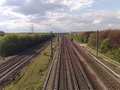
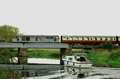
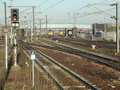
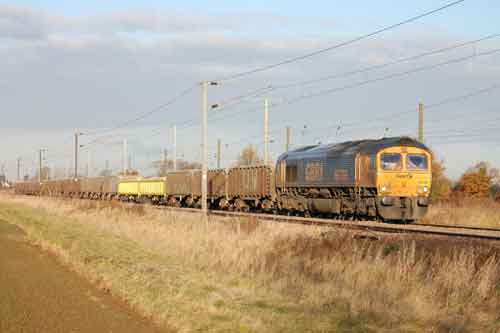
Fig 1 - Looking north east
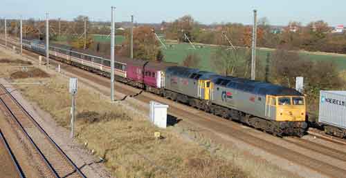
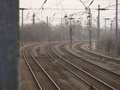
Fig 2 - Looking south east
From the footbridge in summer.
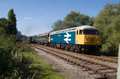
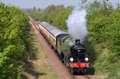
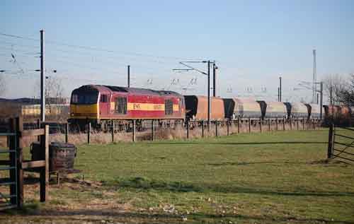
Fig 3 - Looking north west
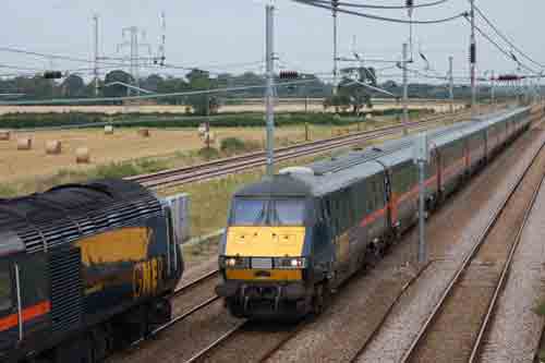
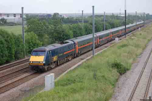
Fig 4 - Looking north east
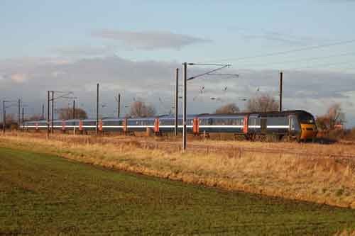
From the road side, winter.
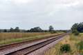
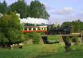
Fig 5 - Looking south west
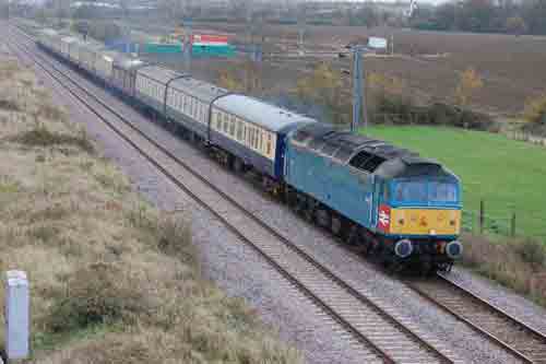
From the footbridge, Autumn
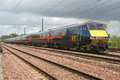
Fig 6 - Looking north east
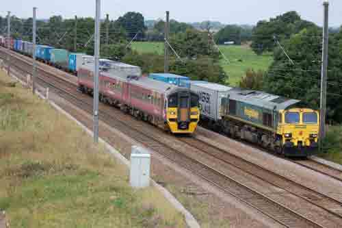
From the foot bridge, summer
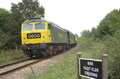
Fig 7 - Looking north east
From the road side, summer
Fig 8 - Looking south east
Disclaimer
All information contained within this is site is © Trainspots. The images used on this site remain the property of the original photographer, as credited at the top of the page, and are used with their kind permission.
The information on these pages is supplied for the benefit of railway enthusiasts who carry out a harmless hobby, and through the medium of photography and video, actually promote the railway industry. Railway enthusiasts can also act as eyes and ears against railway vandalism, and as such should surely be encouraged to do so by the supply of adequate information such as is found on this website.
This site has been created to assist railway photographers in their travels around the country. It is based on the personal knowledge and experience. No liability can be held against the web site or its contributions for incorrect information. Trainspots will endeavour to check all information and corrections will be accepted and posted accordingly.
Advice as to the locations general environment is given as a guide on each page. This information is a GUIDE only. ALWAYS be careful with your equipment, Trainspots can not be held responsible for your personal security. Avoid leaving your property on display for all to see, be aware of your surroundings at all times. There are, sadly, people who will not think twice about trying to steal your equipment.
Trainspots DOES NOT condone trespass and none of the information on this site should be taken as a right to trespass on either railway or private land. To the best of our knowledge all locations are publicly accessible areas, where they are not contact information will be given to the appropriate authority for permission to be obtained.
The content of this site is created and intended for all age ranges but the content of sites linked from this site are not subject to the same intentions. Trainspots will attempt to check links for validity but as time passes and the site grows this will not always be possible. Broken, or indeed updates to, links should be submitted to the editor for inclusion in the updates. All links external to the Trainspots site are opened in a new browser window. Trainspots has been running now for over 10 years and there are imitation sites and guides to railfotspots. But we are a free site and we continue on the path we started out on over a decade ago to provide a useful guide to UK Railway Photographic Locations.