New Mobile Site
We have just launched a new mobile version of this site - m.trainspots. This page will use your smart device's GPS to loctate you and guide you to locations that are close to your present location.
Location notes
Daresbury is approximately 3 miles south of Warrington and about the same distance east of Runcorn. Two lines pass through the area, the West Coast Main Line and the Warrington to Chester line.
Railway type and traffic
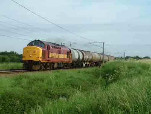
The West Coast Main Line in this area has hourly services to London and Birmingham and most freight services heading south from Warrington Yard. The rest of the southbound freight uses the Chester line which has an hourly service between Manchester and Llandudno.
Environment
The location is semi-rural in that the immediate area is rural but both Runcorn, Warrington and various industrial estates are nearby.
Road directions
From the M56, junction 11:
Head north on the A56 towards Warrington. The first lane on the left leads you to a small crossing on the WCML at Norton, the third on the left, just before the A558 roundabout and signposted Daresbury Laborotory takes you to a bridge over the Chester line.
Click here to set up your location for directions to this location
Daresbury map co-ordinates
Parking
There is a small rough area just before the bridge at Daresbury visible from the bridge, the lane at Norton is a dead end and is not the best area to leave a car but should be fine if car is not too valuable.
Public transport
To reach the crossing at Norton, you need to either catch a train to Runcorn East on the Chester line or catch a bus from Runcorn (Main) station that operates to the busway at Murdishaw. Alight two bus stops after Murdishaw on the busway (the first is Runcorn East Station). Head downhill from this bus stop and the road will take you over the Chester line forming a track towards the WCML. After the crossing there is a canal at a higher level and by going north on the towpath there is a gap in the hedge giving views over the field or after another 200 yards there is a footpath passing through the field and under the WCML which can give views closer to the line. If you carry along the canal you will eventually reach the road at Daresbury (approx. 20-25 minutes walk from the Busway).
Click here to set up your location for directions to this location
Click here to set up your location for directions to this location
Amenities
There are no amenities in the area, the nearest being in the estates of Runcorn.
Sun Compass
Sun Compass using Suncalc by brought to you by Vladimir Agafonkin:
It might be necessary to adjust the time to suit your visit, this link should open with the current day.
Daresbury
Streetmap links
Daresbury general view map
Daresbury close up map
Windows Local Live Link - image quality may vary
Daresbury
It might be necessary to adjust the time to suit your visit, this link should open with the current day.
Daresbury
Googly map
Daresbury general view map
Daresbury close up map
Windows Local Live Link - image quality may vary
Daresbury
Who likes this location on facebook
Railway Gen Group
Photographic notes
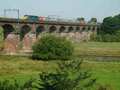
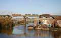
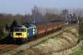
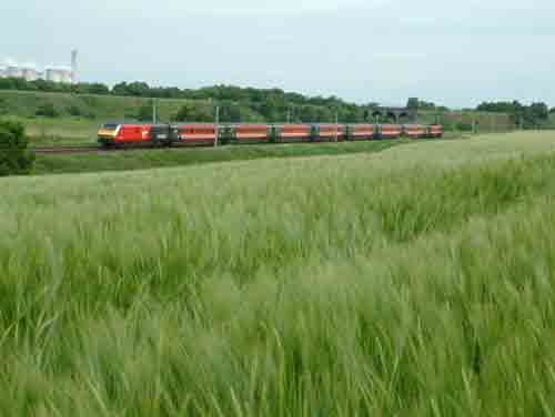
The light at both these locations is best in the morning. The Daresbury bridge (Fig 1) is only suitable for trains from Chester towards Warrington and best early morning. The field (Fig 2) and footpath (Fig 3) at Norton are best for southbound morning trains.
From the footpath across the field video panning can be had of trains on the Chester line as it crosses the WCML on an embankment.
From the footpath across the field video panning can be had of trains on the Chester line as it crosses the WCML on an embankment.
General views - All photographs © Mark Bearton unless otherwise stated
Fig 1 - Looking south
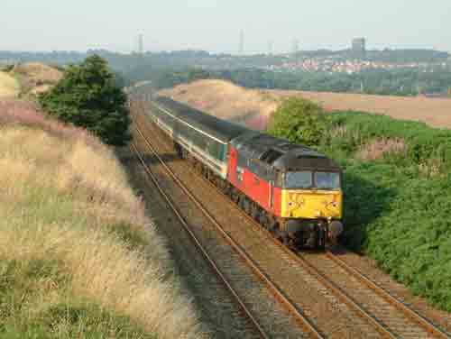
Daresbury Bridge
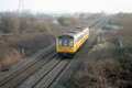
Fig 2 - Looking north
Norton Crossing, this is about a mile south of the Daresbury location.
Fig 3 - Looking south
Norton Crossing - Footpath
Disclaimer
All information contained within this is site is © Trainspots. The images used on this site remain the property of the original photographer, as credited at the top of the page, and are used with their kind permission.
The information on these pages is supplied for the benefit of railway enthusiasts who carry out a harmless hobby, and through the medium of photography and video, actually promote the railway industry. Railway enthusiasts can also act as eyes and ears against railway vandalism, and as such should surely be encouraged to do so by the supply of adequate information such as is found on this website.
This site has been created to assist railway photographers in their travels around the country. It is based on the personal knowledge and experience. No liability can be held against the web site or its contributions for incorrect information. Trainspots will endeavour to check all information and corrections will be accepted and posted accordingly.
Advice as to the locations general environment is given as a guide on each page. This information is a GUIDE only. ALWAYS be careful with your equipment, Trainspots can not be held responsible for your personal security. Avoid leaving your property on display for all to see, be aware of your surroundings at all times. There are, sadly, people who will not think twice about trying to steal your equipment.
Trainspots DOES NOT condone trespass and none of the information on this site should be taken as a right to trespass on either railway or private land. To the best of our knowledge all locations are publicly accessible areas, where they are not contact information will be given to the appropriate authority for permission to be obtained.
The content of this site is created and intended for all age ranges but the content of sites linked from this site are not subject to the same intentions. Trainspots will attempt to check links for validity but as time passes and the site grows this will not always be possible. Broken, or indeed updates to, links should be submitted to the editor for inclusion in the updates. All links external to the Trainspots site are opened in a new browser window. Trainspots has been running now for over 10 years and there are imitation sites and guides to railfotspots. But we are a free site and we continue on the path we started out on over a decade ago to provide a useful guide to UK Railway Photographic Locations.