New Mobile Site
We have just launched a new mobile version of this site - m.trainspots. This page will use your smart device's GPS to loctate you and guide you to locations that are close to your present location.
Location notes
Woburn Sands station is located on the Bedford-Bletchley line, between the stations of Bow Brickhill and Aspley Guise, on the northern outskirts of the village it serves. The platforms are both on the west side of the crossing.
There is a small waiting shelter on platforms which can provide shelter from sudden downpours. There are 4 foot crossings within easy walking distance from the station, the first is to the west of the station, with the other 3 to the east of the station.
There is a small waiting shelter on platforms which can provide shelter from sudden downpours. There are 4 foot crossings within easy walking distance from the station, the first is to the west of the station, with the other 3 to the east of the station.
Railway type and traffic
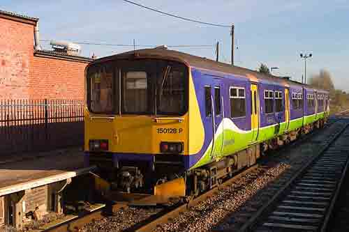
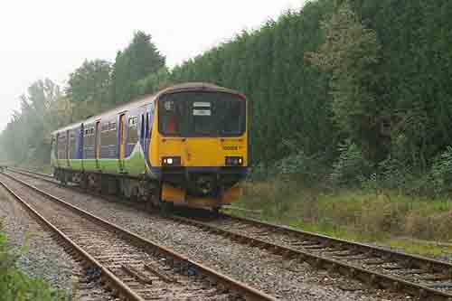
The Bedford Bletchley line is operated by London Midland trains that run a mostly hourly service between the two stations, with all trains stopping at all of the stations on route, Monday to Saturday. Trains stop by request at Kempston Hardwick. There are no scheduled passenger trains on Sunday. These are operated by a small fleet of sprinter 150/1 units.
There are a number of freight workings, the most numerous being DB Schenker departmental workings to and from Forders Virtual Quarry (just to the east of Stewartby station). These workings serve locations on both the WCML and MML.
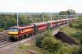
There is also a Tuesday and Friday, at the time of writing, morning Bletchley to Peak Forest stone empties, which leaves Bletchley between 10:20 and 10:40 - although earlier and later timings have been noted.
There are a number of freight workings, the most numerous being DB Schenker departmental workings to and from Forders Virtual Quarry (just to the east of Stewartby station). These workings serve locations on both the WCML and MML.
There is also a Tuesday and Friday, at the time of writing, morning Bletchley to Peak Forest stone empties, which leaves Bletchley between 10:20 and 10:40 - although earlier and later timings have been noted.
Environment
This small station is on the northern outskirts of Woburn sands, with light industry to the north of the station, and housing to the south. The station is quite busy, with local people usually appearing within 5 minutes of the trains due arrival time. There is a small waiting shelter on the platforms which can provide shelter from sudden downpours.
The foot crossing to the west of the station is little used; I've seen one other couple using it on the many occasions I've been in the area, although the track to the north is popular with dog walkers. The first foot crossing to the east of the station is well used by locals to the north of the station to get to the shops to the south of the station, and is adjacent to a playground with all that that entails. The 2nd crossing to the west is in quiet fields, as is the third, and I've never seen either of these used.
The foot crossing to the west of the station is little used; I've seen one other couple using it on the many occasions I've been in the area, although the track to the north is popular with dog walkers. The first foot crossing to the east of the station is well used by locals to the north of the station to get to the shops to the south of the station, and is adjacent to a playground with all that that entails. The 2nd crossing to the west is in quiet fields, as is the third, and I've never seen either of these used.
Road directions
From the M1, Junction 13:
Exit and follow the A421 towards Milton Keynes, at the first roundabout, take the 1st exit (signposted Woburn Sands). Follow this road, Newport Road / A5130, round until you see the crossing gates.
From the A5:
Take the exit sign posted A421, and at the round about on top of the A5 (Readmoor Roundabout), take either the V6 "Grafton Street" or H9 "Groveway". Note this roundabout is likely to be busy, as it's the main access to the new IKEA, ASDA and football ground. If taking the V6 exit, at the next round about, take the 3rd exit along V8 "Standing Way", and continue right along this road until it meets the round-about detailed in the M1 directions (i.e. continue until you see a sign post for Woburn Sands). The same applies with the H9 exit, which meets at the aforementioned roundabout.
Click here to set up your location for directions to this location
Woburn Sands map co-ordinates
Parking
Woburn Sands station doesn't have any parking of its own, so the best place to park is along Cranfield Road which can be found just before the crossing barrier on the left if approaching from the north. There is a long lay-by at the start of this road, which gives easy access to all the foot crossings and station.
Public transport
The station is served by hourly trains from Bedford and Bletchley.
MK Metro service 8 also operates every 30 minutes from Milton Keynes station-note alternate journeys serve Bletchley and do not go to Woburn Sands.
Once there the station is a short walk back along Cranfield Road, and access to either of the platforms is from Newport Road.
The footpath to the west of the station can be gained from a field entrance just to the north of the station - although this isn't an official footpath, the route is well used by local dog walkers. The official footpath, which crosses this, is just past the end of the trees to the south. Follow this south for a short while, crossing the stiles on either side of the line. In wet weather this footpath can become muddy, so suitable footwear should be worn.
The 1st foot crossing to the east of the station is just off Cranfield Road, just as the road turns northward. There is tarmac access to this and through the crossing.
The 2nd foot crossing is a short walk from Cranfield Road. Continuing past the 1st footpath just as the road turns northward there is a small alley which continues through to Vandyke Close. Continue through Vandyke Close and at the eastern most extent of the road is a clearly marked footpath across fields. Follow this footpath until you reach the line. In wet weather this footpath can become muddy, so suitable footwear should be worn.
The 3rd foot crossing is accessed from the 2nd. After crossing the line at the 2nd foot crossing, follow the path across and up the field and you should see the exit of the footpath on the right. This footpath leads to a private road within the Woburn Sands Golf course. Follow this road north for a short while take the first turning on the left past the farm. Just before the road enters the old Woburn Sands water works, is another stile and crossing along the field. Follow this path, and the foot crossing is quite high up on the line. Be careful not to enter the old water works as they are not safe, and there is no shot to be had.
Click here to set up your location for directions to this location
Amenities
There are no amenities on the station but there is a public house very close, and many shops in the main part of Woburn Sands. To the north of the station, a short walk, are two garden centres with toilets and a fairly good restaurant.
Sun Compass
Sun Compass using Suncalc by brought to you by Vladimir Agafonkin:
It might be necessary to adjust the time to suit your visit, this link should open with the current day.
Woburn Sands
Streetmap links
Woburn Sands general view map
Woburn Sands close up map
Windows Local Live Link - image quality may vary
Woburn Sands
It might be necessary to adjust the time to suit your visit, this link should open with the current day.
Woburn Sands
Googly map
Woburn Sands general view map
Woburn Sands close up map
Windows Local Live Link - image quality may vary
Woburn Sands
Who likes this location on facebook
Railway Gen Group
Photographic notes
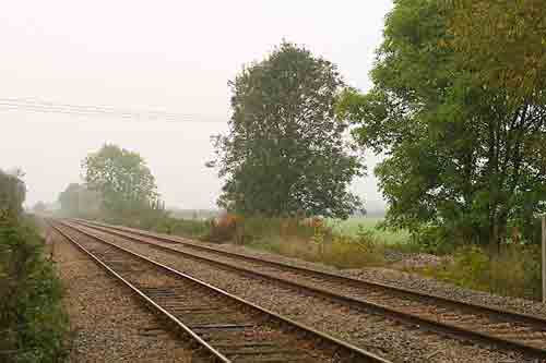
The Bedford Bletchley line is running mainly east-west, but slightly south-east to north-west at this point. Photography is probably best in the morning for east bound traffic, and best in the afternoon for west bound traffic.
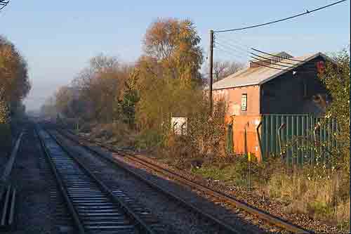
The station is a nice shot, but light can be a problem in winter due to the trees and other buildings in the area. There has been a timing problem of late where the barriers haven't lowered before the freight on Saturday morning is due to cross, so the train is slowed to just before the station, and then opens up through the station as the barriers are eventually lowered - with nice effect. The barriers closing and attendant buzzer indicates the arrival of trains. The road these barriers protect can be quite busy at times, and the drivers in the area aren't known for their patience, so videoing may include the sound of revving engines.
The foot crossing to the west of the station is in quite a wooded area, which makes a nice backdrop during the summer but presents many shadow problems in the winter. Most of the east bound trains are slowing at this point.
The foot crossing to the east of the station is in a built-up area, but it is possible to get shots of the train passing through the barriers as it makes its way towards Bedford. There is a large row of Conifers to the east of this crossing making an effective sun block.
The 2nd foot crossing to the east of the station is in a lightly wooded area, and which provides nice dappled patterns in the summer, and nice foliage in the autumn, but again can be problems in winter and spring. To take photographs in this location you must be on the inside of the fence, although still on the crossing, as the fence is too far back.
The 3rd foot crossing to the east of the station is on a raised embankment, which provides a lot of light, especially during the winter months. As with the 2nd foot crossing, one must be inside the fence to take a shot, as the fence starts at the foot of the embankment.
General views - All photographs © Richard Tearle unless otherwise stated
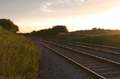
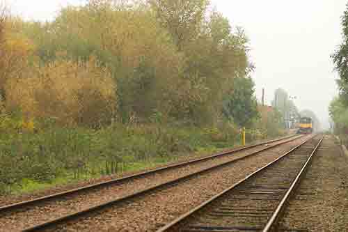
Fig 1 - Looking west - station
This is the east facing view from the southern side of the line, on the Bletchley bound platform. This shows the problem with light in the winter, but the not unattractive background here.
This was taken in November at 10:32 with a 50mm lens.
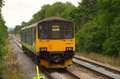
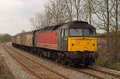
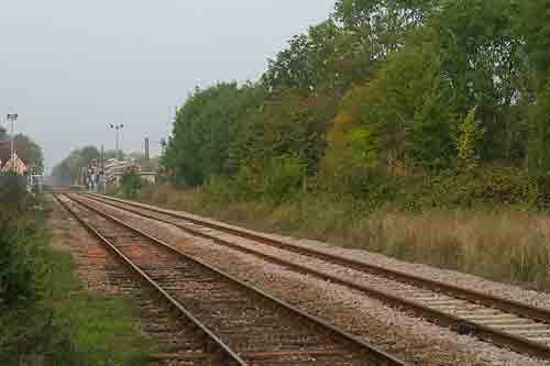
Fig 2 - Looking east - station
This is the west facing view from the southern side of the line, on the Bletchley bound platform.
This was taken in November at 11:09 with a 35mm lens.
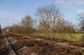
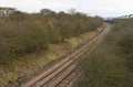
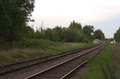
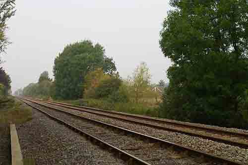
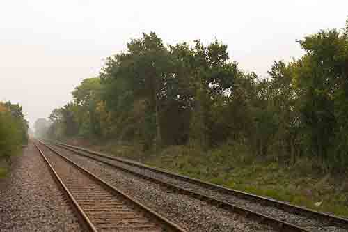
Fig 3 - Looking west - western footpath
This is the east facing view from the southern side of the line, showing quite a sharp curve in the far distance.
This was taken in October at 10:00 with a 50mm lens.
Fig 4 - Looking east - western footpath
This is the west facing view from the southern side of the line, showing the station and barriers beyond.
This was taken in October at 10:00 with a 70mm lens.
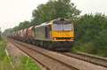
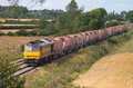
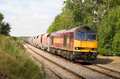
Fig 5 - Looking west - eastern footpath #1
This is the east facing view from the southern side of the line, showing barriers and station in the near distance.
This was taken in October at 09:00 with a 50mm lens.
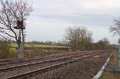
Fig 6 - Looking east - eastern footpath #1
This is the west facing view from the northern side of the line, showing the high hedge. This shot doesn't show that the line continues fairly straight to the next foot crossing.
This was taken in October at 09:00 with a 50mm lens.
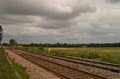
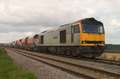
Fig 7 - Looking west - eastern footpath #2
This is the east facing view from the southern side of the line, showing barriers and station in the far distance.
This was taken in October at 09:10 with a 35mm lens.
Fig 8 - Looking east - eastern footpath #2
This is the west facing view from the northern side of the line, showing the very straight part of the line.
This was taken in October at 09:10 with a 35mm lens.
Disclaimer
All information contained within this is site is © Trainspots. The images used on this site remain the property of the original photographer, as credited at the top of the page, and are used with their kind permission.
The information on these pages is supplied for the benefit of railway enthusiasts who carry out a harmless hobby, and through the medium of photography and video, actually promote the railway industry. Railway enthusiasts can also act as eyes and ears against railway vandalism, and as such should surely be encouraged to do so by the supply of adequate information such as is found on this website.
This site has been created to assist railway photographers in their travels around the country. It is based on the personal knowledge and experience. No liability can be held against the web site or its contributions for incorrect information. Trainspots will endeavour to check all information and corrections will be accepted and posted accordingly.
Advice as to the locations general environment is given as a guide on each page. This information is a GUIDE only. ALWAYS be careful with your equipment, Trainspots can not be held responsible for your personal security. Avoid leaving your property on display for all to see, be aware of your surroundings at all times. There are, sadly, people who will not think twice about trying to steal your equipment.
Trainspots DOES NOT condone trespass and none of the information on this site should be taken as a right to trespass on either railway or private land. To the best of our knowledge all locations are publicly accessible areas, where they are not contact information will be given to the appropriate authority for permission to be obtained.
The content of this site is created and intended for all age ranges but the content of sites linked from this site are not subject to the same intentions. Trainspots will attempt to check links for validity but as time passes and the site grows this will not always be possible. Broken, or indeed updates to, links should be submitted to the editor for inclusion in the updates. All links external to the Trainspots site are opened in a new browser window. Trainspots has been running now for over 10 years and there are imitation sites and guides to railfotspots. But we are a free site and we continue on the path we started out on over a decade ago to provide a useful guide to UK Railway Photographic Locations.