New Mobile Site
We have just launched a new mobile version of this site - m.trainspots. This page will use your smart device's GPS to loctate you and guide you to locations that are close to your present location.
Location notes
A foot bridge over the line, where the railway crosses the river Great Ouse, in Bedford Town Center.
Railway type and traffic
The Bedford to Bletchley line is operated by London Midland trains that run a mostly hourly service between the two stations. Trains stop by request at Kempston Hardwick. There are no scheduled passenger trains on Sunday. These are operated by a small fleet of either 150 or 153 units.
Frieght is currently sparse along the route, but it frequently used by workings heading from the Midland Main line traveling to the south, cutting across to Bletchley.
Environment
A well used foot path between two sections of Bedford. The footpath also passes under the railway line so most people tend to take the underpass and avoid the bridge.
Road directions
From the A421 take the A6 junction into Bedford Town Centre and follow this road until you reach the roundabout just after Bedford St Johns Station, unless you can get in the small car park there. At the roundabout take the first exit and follow the signs for the 'Town Centre/Midland Station'. You will drive past the location on your left, but there are no suitable places to park untill the station.
Click here to set up your location for directions to this location
Bedford, Great Ouse Crossing map co-ordinates
Click here to set up your location for directions to this location
Bedford, Great Ouse Crossing map co-ordinates
Parking
As well as the Midland and St Johns station car parks there is underground parking in Horne Lane, multi-storey car park in River street. There are also a couple of car parks in the immediate area but check the restrictions carefully before parking. Most of the roads are private with residential restrictions. The more affordable car parks are quite some distance walk from the location, within the town centre.
Horne Lane, you pay up front, River street gives you a plastic chip coin which you use to pay then use to exit after you paid. Both are 5 mins walk from the location. Just cross the road towards the river (you can walk through the NEW Vue cinema and turn right) and walk along the embankment, under Prebend Street bridge and you are there.
*note the cinema may not appear on maps on the map, it was built in late 2017.
Public transport
First Capital Connect and East Midlands Trains operates into Bedford's 'Midland' station, with London Midland serving the actual Bedford to Bletchley 'branch'. Both the Midland and St. John Station are about a 10 minute walk from the location. But given the frequency of services the walk would be better from the Midland Station.
From Bedford Midland Station:
Exit the station and turn right, heading down Ashburnham Road. At the mini roundabout follow the road left as it changes to Midland Road and then take the next right at the roundabout onto Prebend Street and follow this road to the river, from here there is a ramp on the right that leads to the location.
Click here to set up your location for directions to this location
Amenities
There is nothing at the location, but the town centre is about 10 minutes walk away where you should be able to find anything you might need. There are toilets are nearer Horne Lane entrance into Harpur Shopping Centre and are practically located at the rear of the car park as you enter the shopping centre.
Accommodation
There is a travel lodge type hotel just off the A421/A6 roundabout.
Sun Compass
Sun Compass using Suncalc by brought to you by Vladimir Agafonkin:
It might be necessary to adjust the time to suit your visit, this link should open with the current day.
Bedford, Great Ouse Crossing
Streetmap links
Bedford, Great Ouse Crossing general view map
Bedford, Great Ouse Crossing close up map
Windows Local Live Link - image quality may vary
Bedford, Great Ouse Crossing
It might be necessary to adjust the time to suit your visit, this link should open with the current day.
Bedford, Great Ouse Crossing
Googly map
Bedford, Great Ouse Crossing general view map
Bedford, Great Ouse Crossing close up map
Windows Local Live Link - image quality may vary
Bedford, Great Ouse Crossing
Who likes this location on facebook
Railway Gen Group
Photographic notes
The primary shot here is from the eastern side of the line. Either from the footbridge or it's steps or from the river bank. It is worth noting though, if shooting from the bank that the bridge sides are roughly the same height as a platform and will, as such, obscure the view of the trains bogies and underframes.
There may well be shots from the southern river bank, but as yet access to the area has yet to be determined.
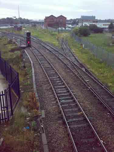
The signal to the north of the location has a 'theatre box' which will indicate 'B' for the bay platform, which is standard for local units. Anything else will be routed out into the main platforms and will probably not be a local unit!
There may well be shots from the southern river bank, but as yet access to the area has yet to be determined.
The signal to the north of the location has a 'theatre box' which will indicate 'B' for the bay platform, which is standard for local units. Anything else will be routed out into the main platforms and will probably not be a local unit!
General views - All photographs © Marcus Dawson unless otherwise stated
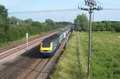
Fig 1 - Looking north - Image © Richard Stringer
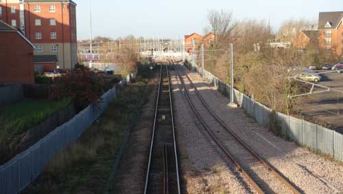
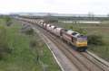
Fig 2 - Looking east - Image © Richard Stringer
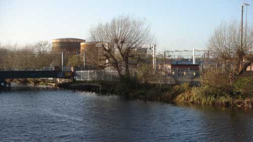
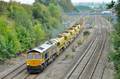
Fig 3 - Looking south
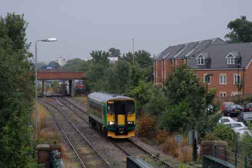
Fig 4 - Looking south
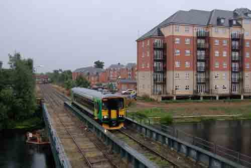
Fig 5 - Looking north
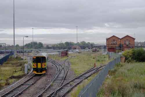
Fig 6 - Looking south
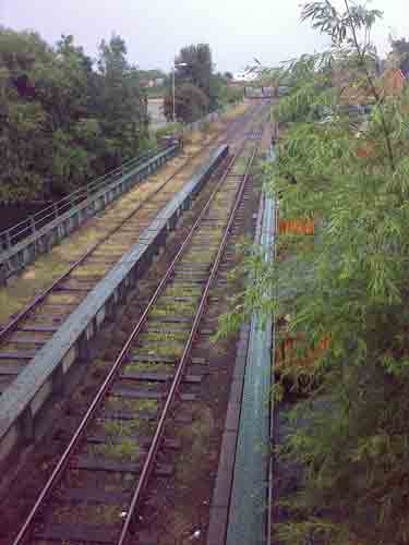
From the western side of the foot bridge, showing the restricted view due to the tree growth.
Fig 7 - Looking north
From the western side of the bridge.
Disclaimer
All information contained within this is site is © Trainspots. The images used on this site remain the property of the original photographer, as credited at the top of the page, and are used with their kind permission.
The information on these pages is supplied for the benefit of railway enthusiasts who carry out a harmless hobby, and through the medium of photography and video, actually promote the railway industry. Railway enthusiasts can also act as eyes and ears against railway vandalism, and as such should surely be encouraged to do so by the supply of adequate information such as is found on this website.
This site has been created to assist railway photographers in their travels around the country. It is based on the personal knowledge and experience. No liability can be held against the web site or its contributions for incorrect information. Trainspots will endeavour to check all information and corrections will be accepted and posted accordingly.
Advice as to the locations general environment is given as a guide on each page. This information is a GUIDE only. ALWAYS be careful with your equipment, Trainspots can not be held responsible for your personal security. Avoid leaving your property on display for all to see, be aware of your surroundings at all times. There are, sadly, people who will not think twice about trying to steal your equipment.
Trainspots DOES NOT condone trespass and none of the information on this site should be taken as a right to trespass on either railway or private land. To the best of our knowledge all locations are publicly accessible areas, where they are not contact information will be given to the appropriate authority for permission to be obtained.
The content of this site is created and intended for all age ranges but the content of sites linked from this site are not subject to the same intentions. Trainspots will attempt to check links for validity but as time passes and the site grows this will not always be possible. Broken, or indeed updates to, links should be submitted to the editor for inclusion in the updates. All links external to the Trainspots site are opened in a new browser window. Trainspots has been running now for over 10 years and there are imitation sites and guides to railfotspots. But we are a free site and we continue on the path we started out on over a decade ago to provide a useful guide to UK Railway Photographic Locations.