New Mobile Site
We have just launched a new mobile version of this site - m.trainspots. This page will use your smart device's GPS to loctate you and guide you to locations that are close to your present location.
Location notes
Bogborough is located on the Bedford-Bletchley line, between the stations of Ridgmont and Lidlington, just off the M1 Junction 13. This is the only other bridge over the line, other than the A507 on the western half of the branch.
There is nowhere to shelter should the weather turn nasty.
There is nowhere to shelter should the weather turn nasty.
Railway type and traffic
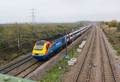
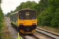
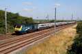
The Bedford Bletchley line is operated by London Midland trains that run a mostly hourly service between the two stations, with all trains stopping at all of the stations on route, Monday to Saturday. Trains stop by request at Kempston Hardwick. There are no scheduled passenger trains on Sunday. These are operated by a small fleet of sprinter 150/1 units.
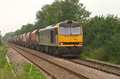
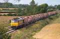
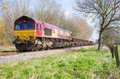
There are a number of freight workings, the most numerous being DB Schenker departmental workings to and from Forders Virtual Quarry (just to the east of Stewartby station). These workings serve locations on both the WCML and MML.
There is also a Tuesday and Friday, at the time of writing, morning Bletchley to Peak Forest stone empties, which leaves Bletchley between 10:20 and 10:40 - although earlier and later timings have been noted.
Environment
The bridge over the line at Bogborough is on the edge of a large playing which itself is on the edge of Bogborough Village. There are plenty of motorcycle tracks in the area, so it might not be too wise to hang around the area during the evenings; the area is quite safe during the day as the playing field is usually full of dog walkers.
Road directions
From the M1, Junction 13:
Exit the motorway and head north on the A421 and turn right along Highfield Road just after entering Bogborough village (just after the 50mph speed limit signs). Follow this road around and at the mini-roundabout turn right, and follow the road into a small parking area adjacent to the playground. There are further parking spaces at the other end of Ridgway Road.
Once parked at the playground, follow the well marked footpath past the edge of the warehouses (and not between), until you come to the end of the warehouses and a crossroads of footpaths. Take the right hand path and follow this up the bank, continue between the low fences (protecting the newly planted trees), until you come to a private road that connects the farm (over the bridge), to the A421. Walk along the road until you reach the bridge. Don't be tempted to drive along the road as this is private road, and the farmer is no friend of railway enthusiasts.
Click here to set up your location for directions to this location
Bogborough map co-ordinates
Parking
Park either on Ridgway Road, or in the small car park at either end of this road. It's also possible to walk from Lidlington following the footpaths, which might be a safer place to park ones car.
Public transport
By far the easiest way to this location is to use the rail service from either Bletchley or Bedford and alight at either Ridgmont station or Lidlington. There is a footpath through the middle of the business park adjacent to Ridgmont station, that will bring you to the playground / car park mentioned above.
Click here to set up your location for directions to this location
Click here to set up your location for directions to this location
Amenities
There is a row of local shops just off the A421 in the village itself.
Sun Compass
Sun Compass using Suncalc by brought to you by Vladimir Agafonkin:
It might be necessary to adjust the time to suit your visit, this link should open with the current day.
Bogborough
Streetmap links
Bogborough general view map
Bogborough close up map
Windows Local Live Link - image quality may vary
Bogborough
It might be necessary to adjust the time to suit your visit, this link should open with the current day.
Bogborough
Googly map
Bogborough general view map
Bogborough close up map
Windows Local Live Link - image quality may vary
Bogborough
Who likes this location on facebook
Railway Gen Group
Photographic notes
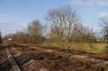
The bridge is quite high over the line, and serves a farm on the southern side of the line. The line to the west is quite overgrown by trees and curves somewhat, but the view to the east is clear of trees and straight for quite a while.
General views - All photographs © Richard Tearle unless otherwise stated
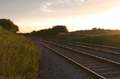
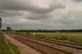
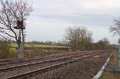
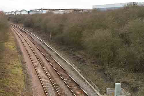
Fig 1 - Looking west
This is the west facing view from the northern side of the line, showing the curve and the trees that block this view.
This was taken in March at 17:15 with a 35mm lens.
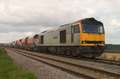
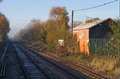
Fig 2 - Looking west
This is the west facing view from the southern side of the line, again showing the curve.
This was taken in March at 17:15 with a 35mm lens.
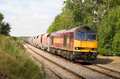
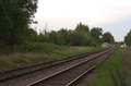
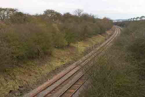
Fig 3 - Looking east
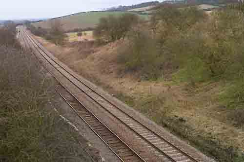
This is the east facing view from the northern side of the line, showing the straight length here, and the more open nature of the area.
This was taken in March at 17:15 with a 35mm lens.
Disclaimer
All information contained within this is site is © Trainspots. The images used on this site remain the property of the original photographer, as credited at the top of the page, and are used with their kind permission.
The information on these pages is supplied for the benefit of railway enthusiasts who carry out a harmless hobby, and through the medium of photography and video, actually promote the railway industry. Railway enthusiasts can also act as eyes and ears against railway vandalism, and as such should surely be encouraged to do so by the supply of adequate information such as is found on this website.
This site has been created to assist railway photographers in their travels around the country. It is based on the personal knowledge and experience. No liability can be held against the web site or its contributions for incorrect information. Trainspots will endeavour to check all information and corrections will be accepted and posted accordingly.
Advice as to the locations general environment is given as a guide on each page. This information is a GUIDE only. ALWAYS be careful with your equipment, Trainspots can not be held responsible for your personal security. Avoid leaving your property on display for all to see, be aware of your surroundings at all times. There are, sadly, people who will not think twice about trying to steal your equipment.
Trainspots DOES NOT condone trespass and none of the information on this site should be taken as a right to trespass on either railway or private land. To the best of our knowledge all locations are publicly accessible areas, where they are not contact information will be given to the appropriate authority for permission to be obtained.
The content of this site is created and intended for all age ranges but the content of sites linked from this site are not subject to the same intentions. Trainspots will attempt to check links for validity but as time passes and the site grows this will not always be possible. Broken, or indeed updates to, links should be submitted to the editor for inclusion in the updates. All links external to the Trainspots site are opened in a new browser window. Trainspots has been running now for over 10 years and there are imitation sites and guides to railfotspots. But we are a free site and we continue on the path we started out on over a decade ago to provide a useful guide to UK Railway Photographic Locations.